Quévillon
The Quevillon property is 50% owned by Osisko Mining Inc. and consists of 2815 individual claims covering an area of 150,163 hectares (figure 1). The Quevillon project, located at the boundary between Eeyou Istchee James Bay territory and the Abitibi-Témiscamingue administrative region, can be subdivided into two blocks of claims, the Central and Northeastern Blocks. The Central Block surrounds the town of Lebel-sur-Quévillon and contains the Osborne-Bell deposit. The Northeastern Block is separated in three sectors and extends from the settlement of Miquelon to the town of Waswanipi. Access to the Quevillon property can be achieved by headling eastbound from Val-d’Or on the paved Highway 117 for about 30 km, then northbound on the paved Highway 113 for about 125 km where is located the town of Lebel-sur-Quévillon. The Quevillon project falls within the traditional territory of the Lac Simon Anishnabe First Nation and the Cree First Nation of Waswanipi.
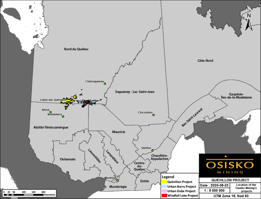
Figure 1: Location of the Quévillon gold project.
Key Facts
The Quévillon Project comprises the Osborne-Bell Gold Deposit as well as several gold showing.
Project Description
Geology
GEOLOGY
The Quevillon project is located in the Abitibi Subprovince, in the North Volcanic Zone (figure 2). The property is mostly characterized by extensive pillowed, massive, or brecciated basaltic sequences intruded by synvolcanic and cogenetic mafic to ultramafic sills and dikes. This mafic volcanic pile is thick, effusive, and generally non-explosive which suggests a submarine basalt plain environment. Few felsic to intermediate volcanic edifices occur within the mafic sequence.
The Quevillon project is associated with the junction of numerous major structures that include the Casa Berardi, Laflamme, Rivière Kiask and Cameron shear zones which are mostly oriented WNW-ESE. The Lamarck-Wedding fault borders the northern portion of the Northeastern Block and passes through the Central Block of claims. This deformation corridor has an uncommon NE-SW trend and truncates the WNW-ESE deformation zones.
The area surrounding the Osborne-Bell deposit is part of the Vanier-Dalet-Poirier Group and is dominated by undifferentiated mafic and intermediate volcanic rocks of basaltic to andesitic composition. Felsic volcanic and volcaniclastic rocks of dacitic to rhyolitic compositions, and local interlayers of various sedimentary rocks (argillites, graphitic shales, and iron formations) have also been documented. The rocks are metamorphosed to the greenschist facies and can reach amphibolite facies at the margins of late intrusive stocks.
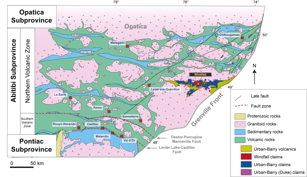
Figure 2: Regional geology of the Northern Volcanic Zone and the locations of the Windfall, Urban-Barry, and Quévillon projects.
Stratigraphy
The Osborne-Bell deposit is associated with synvolcanic felsic units enclosed within a broad package of intermediate to mafic volcanic rocks. Both are affected by various intensities of deformation and alteration. The south is bounded by the post-tectonic Beehler Stock which truncates the volcanic sequence. A swarm of feldspar-amphibole porphyry dikes related to the Beehler Stock also cross-cuts the synvolcanic sequence. Late aplite and lamprophyre dikes cross-cut all the units above (figure 3).
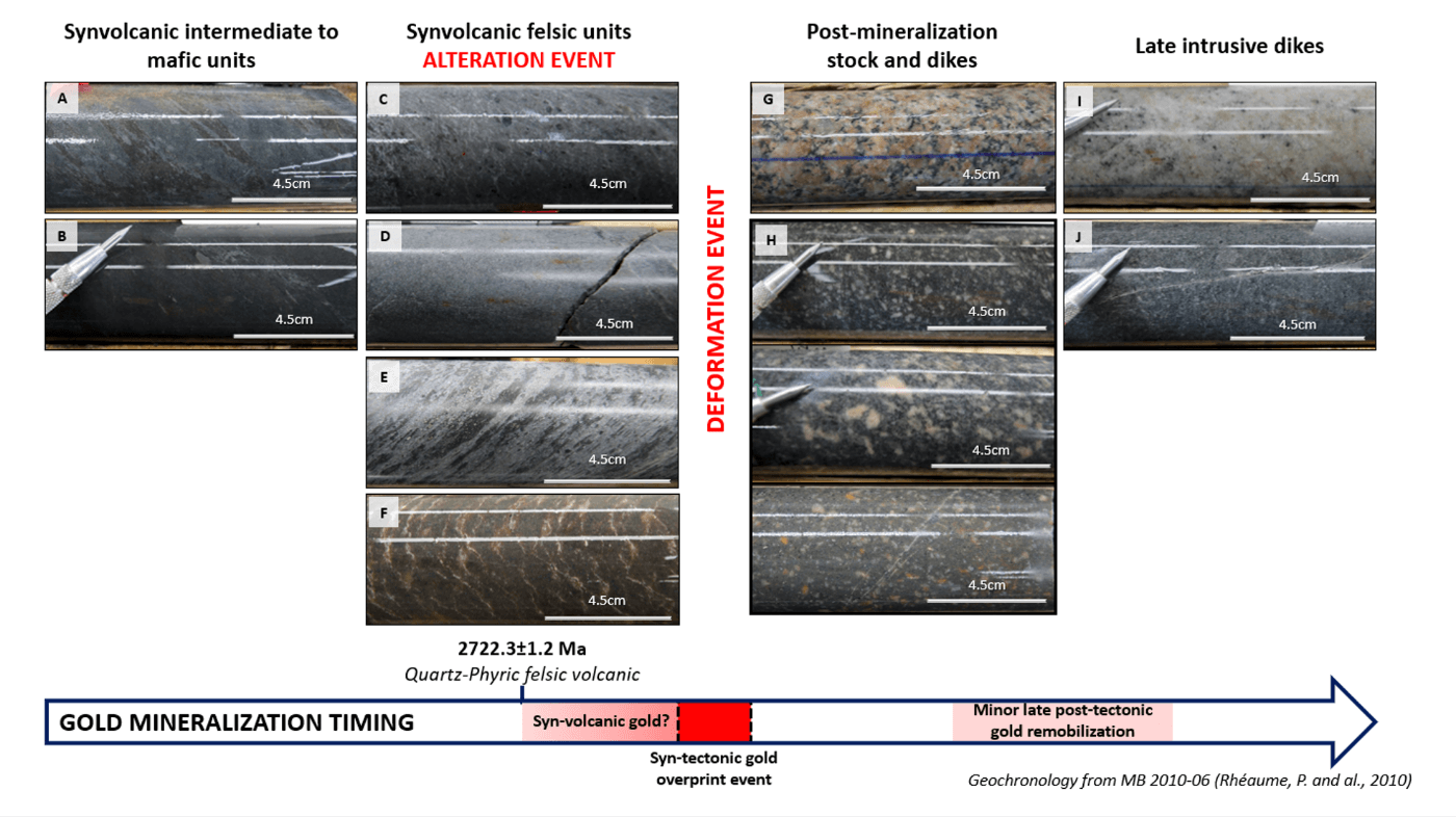
Figure 3: Types of rock encountered at the Osborne-Bell deposit according to cross-cutting relationships. A) Moderately foliated volcaniclastic andesite displaying weak silicification accompanied by biotitization. B) Weakly foliated massive andesite. C) Weakly foliated quartz-phyric rhyodacite with moderate sericite-silica alteration. D) Unfoliated to weakly foliated aphyric rhyodacite displaying weak sericitization and silicification. E) Moderately foliated brecciated rhyodacite. F) “Zebra” rhyolite showing a dense stockwork of pale micro-cracks subparallel to the general foliation. G) Unfoliated and weakly hematized Beelher Stock. H) Three different facies of unfoliated feldspar-amphibole porphyry dikes. I) Unfoliated and fine-grained aplite dike. J) Unfoliated and fine-grained lamprophyre dike.
Intermediate to mafic volcanics
Intermediate to mafic volcaniclastic and massive units represent the greatest volume of Osborne-Bell volcanic rocks. The rock is commonly fine-grained and moderately foliated. The massive unit is mostly observed north of the felsic package.
The volcaniclastic unit is the most voluminous mafic facies at Osborne-Bell and occur on both side of the felsic package. Their visual appearance is characterized by coloured bands ranging from dark grey to hues of green and plum. Chlorite-altered elongated clasts (lapilli to block sizes) are common features and allow easy observation of the foliated texture. The matrix displays a weak and pervasive silicification accompanied by a biotitization. Felsic fragments or silica-altered clasts, when present, can represent up to 15% of the rock and are characterized by a strong silica-sericite alteration.
Felsic volcanics
Quartz-phyric rhyodacite
The quartz-phyric rhyodacite represents a major part of the felsic package. The unit has been documented in drill core along the entire trend for 1.9 km and constitutes the deepest felsic rock encountered to date at Osborne-Bell. The thickness of the pile can reach 100 m. The unit contains up to 10% millimetre-scale blue quartz porphyries. At the western end of Osborne-Bell, the unit may also contain 2-15% feldspar phenocrysts. The texture is generally massive or weakly to moderately foliated. The unit is strongly altered by sericite and silica.
Aphyric rhyodacite
The aphyric rhyodacite typically occurs adjacent and/or intercalated with the quartz-phyric felsic facies. The E-W lateral continuity of the unit is limited in extent from tens of metres to 100 m, and thickness varies from metres to tens of metres. The aphyric rhyodacite displays alteration and deformation patterns very similar to those of the quartz-phyric felsic unit.
Brecciated rhyodacite
The brecciated rhyodacite contains intermediate to felsic fragments. The unit displays a strong sericitization with some siliceous bands. A well-developed foliated texture is observed. This facies is associated with other felsic volcanic facies but has also been documented within mafic volcanic rock as thin isolated intervals.
Zebra Felsic Unit
The zebra unit is found in the central and eastern end of Osborne-Bell. It cross-cuts across both intermediate to mafic and felsic volcanic packages. This uncommon weakly magnetic, foliated, greyish-purple aphyric rock is characterized by a dense stockwork of pale micro-cracks displaying a preferential orientation subparallel to the general foliation. This unit is thought to represent one of the last episodes of synvolcanic felsic magmatism.
Late intrusive rock
Beelher Stock
The Beelher stock has a monzonitic to granodioritic composition and is thought to be late to post-tectonic. It intrudes and truncates the volcanic stratigraphy. The rock is characterized by an unfoliated intergranular texture with 20-30% coarse feldspar phenocrysts and up to 8% ferromagnesian mineral such as amphibole and chlorite. An important swarm of feldspar-amphibole porphyry dikes occur along the northern margin of this intrusion and may be cogenetic with the latter.
Feldspar-amphibole porphyry dikes
The feldspar-amphibole porphyry dikes have the same geochemical composition as the Beehler stock. Additionally, occurrences of these dikes gradually increase closer to the Beelher Stock. Those observations suggest the cogenetic link between the two. Their unfoliated texture indicates they were not affected by the various phases of penetrative deformation affecting other rocks in the area, indicating a late to post-tectonic age of emplacement. The dikes range from decimetres to several metres thick. The fine-grained matrix contains 3-20% feldspar phenocrysts and 3-8% ferromagnesian phenocrysts such as amphibole and chlorite. Their colour ranges from grey to shades of red, the intensity depending on the degree of hematization.
Aplite/pegmatite
In addition to the dominant porphyritic phase of the Beelher, lesser amounts of aplite and pegmatite dikes were also observed. Those dikes crosscut the volcanic units and feldspar-amphibole porphyry dikes. The aplite dikes are generally fine-grained, massive, and homogenous. They contain 2-5% ferromagnesian minerals. The pegmatite dikes contain coarse quartz and white to reddish feldspar crystals, and traces of non-magnetic ferromagnesian minerals.
Lamprophyre
Rare grey to dark lamprophyre dikes cross-cut all other lithological units. The calcite-rich matrix is fine-grained and contains sub-millimetre amphibole phenocrysts. An absence of secondary tectonic fabric indicates a late stage of emplacement.
Gold Mineralization
The Osborne-Bell deposit consists of a disseminated pyrite gold deposit and therefore not a typical Archean lode gold deposit like those generally found in the Abitibi Belt. Although there has been some great improvement in the understanding of this deposit type in recent years, the origin of the Osborne-Bell gold and its geological controls are not yet fully understood.
The sulphide-rich gold mineralization of the Osborne-Bell deposit extends over a 1,900-metres strike length with the mineralization in the eastern part oriented in a N276° direction with a steep (80°) dip to the north and the mineralization in the extreme western part oriented in a N310° direction with a steep (72°) dip to the northeast. The extent of the mineralization is up to 430 m wide and is known to a vertical depth of 1,300 m below surface in the eastern part of the deposit.
Mineralization includes disseminated sulphides, concentration of sulphides in millimetre- to centimetre-scale lenses, and millimetre-scale stringers and veinlets of fined grained sulphides. Sulphide minerals are typically pyrite with some pyrrhotite, chalcopyrite, and sphalerite. Higher gold grades are generally associated with the presence of 5-10% sulphides mainly occurring as sulphide stringers and veinlets with minor chlorite (figure 4).
Most of the mineralization occurs in the synvolcanic felsic units and at the contacts with the surrounding intermediate to mafic volcanic rocks. Intermediate to mafic volcanic units can also be mineralized up to several tens of metres from the contact to the felsic rocks. Gold mineralization is strongly controlled by the schistosity within the volcanic units. A swarm of late- to post-tectonic dikes cross-cut the synvolcanic sequence. Frequent high-grade gold intervals occur near the contact between the volcanic rocks and the dikes. These probably played a role in the late to post-tectonic gold remobilization but are not related to the main gold mineralization event.
At Osborne-Bell, the gold mineralization is defined within 9 mineralized lenses separated in 3 areas (series 1- to 3-) (figure 5). The zones have been defined according a minimum true width of 2 metres and a cut-off grade of 3.0 g/t Au.
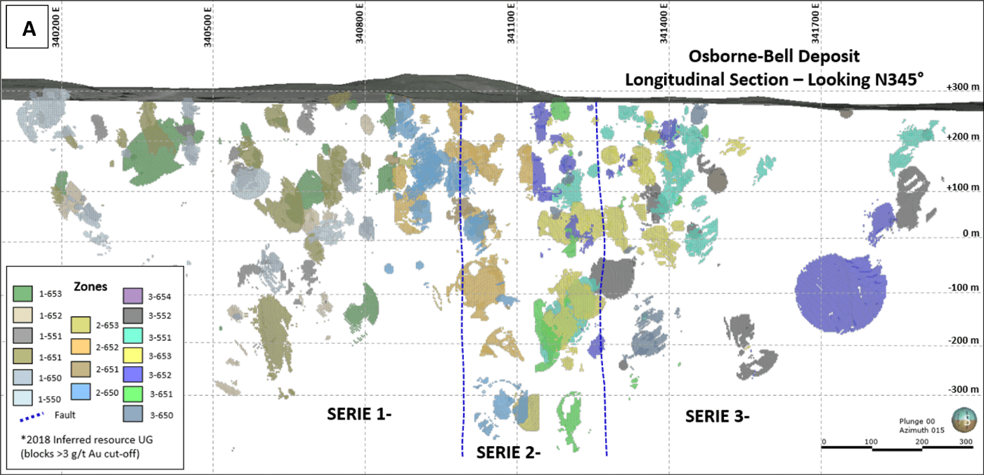
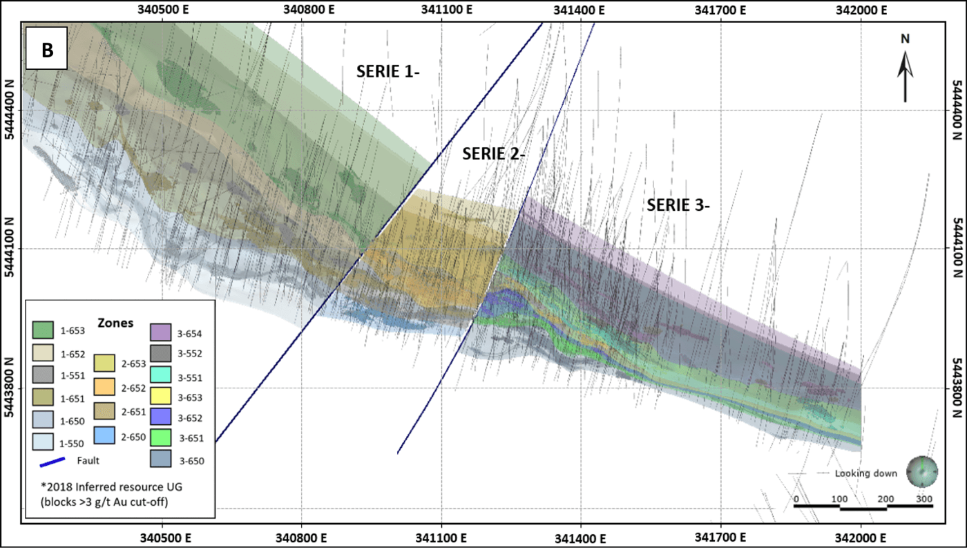
Figure 4: A) Longitudinal view (looking N345°) showing the 2018 Inferred Resources with a classification based on the modeled mineralized envelops, and B) Plan view of the modeled mineralized envelops superimposed on the 2018 Inferred Resources. All the drill hole traces are displayed in light grey.
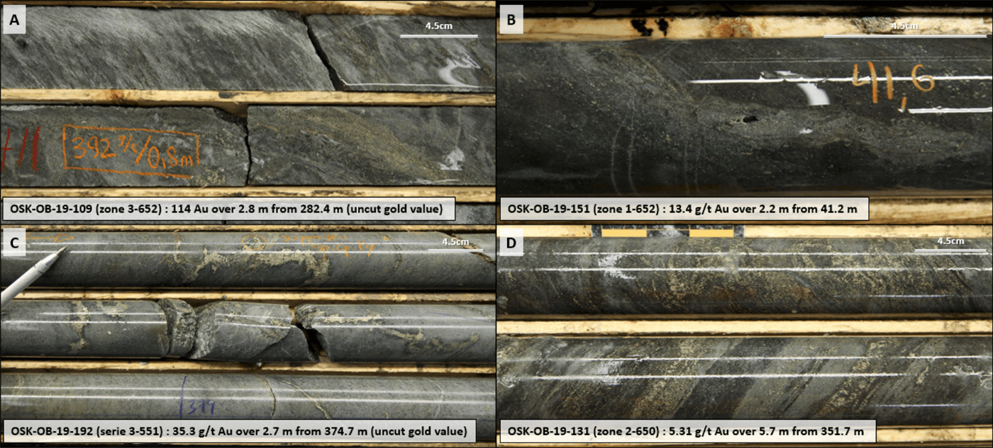
Figure 5: Mineralized textures encountered at Osborne-Bell deposit (from Osisko Mining 2019 definition drilling campaign). A) Moderately altered chlorite-biotite altered quartz-phyric rhyodacite hosting up to 5% disseminated pyrite and up to 15% pyrite±sphalerite concentrated within a centimetre-scale vein. Few specks of visible gold occur along the vein. B) Weakly biotite-sericite-chlorite altered andesite hosting 2% disseminated pyrite and chlorite-pyrite veinlets (CPV). Specks of gold is associated with the CPV. C) Moderately sericite-chlorite altered quartz-phyric rhyodacite hosting 6% pyrite, 2% chalcopyrite and traces of sphalerite within folded and low-angle chlorite-carbonate veinlets. D) Weakly sericite-silica-chlorite altered andesite hosting up to 15% pyrite and traces of sphalerite concentrated within centimetre-scale veinlets.
Mineral Resource Estimate
March 2018 Mineral Resource Estimate Update
- Inferred Resource: 2.587 Mt at 6.13 g/t Au for 510 000 oz Au assuming US$1,300 per ounce gold price and a lower cut-off grade of 3.0 g/t Au
Osborne Bell Deposit Inferred Mineral Resource Estimate
Table 1: Osborne-Bell Gold Deposit Inferred Mineral Resources

Notes:
- Values are rounded to nearest thousand which may cause apparent discrepancies.
Osborne-Bell Mineral Resource Estimate notes:
- The Independent and qualified Person for the Mineral Resource Estimate, as defined by NI 43‑101, is Pierre-Luc Richard, P.Geo., M.Sc. (InnovExplo Inc.), and the effective date of the Estimate is March 2, 2018.
- These mineral resources are not mineral reserves as they do not have demonstrated economic viability.
- While the results are presented undiluted and in situ, the reported mineral resources are considered to have reasonable prospects for economic extraction.
- The estimate encompasses nine (9) gold-bearing zones each defined by individual wireframes with a minimum true thickness of 2 metres.
- High grade capping was done on composite data and established on a per zone basis for gold. It varies from 25 to 55 g/t.
- Density values were applied on the following lithological basis (g/cm3): volcanic rocks = 2.80; late barren dykes and Beehler stock = 2.78; Zebra felsic unit = 2.72.
- Grade model resource estimation was evaluated from drill holes using an OK interpolation method in a block model (block size = 2.5 x 2.5 x 2.5 m).
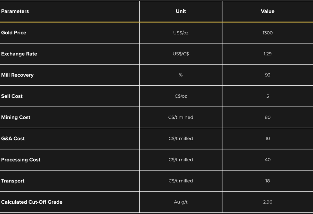
- Underground resource estimation is reported at 3.00 g/t Au cut-off. The cut-off calculation is based on following assumptions: Mining cost = C$80; Processing cost = C$40; General and Administration= C$10. For calculating cut-off grades, the following parameters were used: gold price of US$1,300/oz and exchange rate of USD:CAD = 1.29 inspired from the 1-year trailing average. Cut-off grades will have to be re-evaluated in light of future prevailing market conditions (metal prices, exchange rate and mining cost, etc.).
- The Mineral Resources presented herein are categorized as Inferred. The Inferred category is only defined within the areas where drill spacing is less than 100m and shows sufficient geological and grade continuity.
- The resource was estimated using Geovia GEMS 6.8. The estimate is based on 931 surface diamond drill holes. A minimum true thickness of 2.0 m was applied, using the grade of the adjacent material when assayed, or a value of zero when not assayed.
- Calculations used metric units (metres, tonnes and g/t). Metal contents are presented in troy ounces (metric ton x grade / 31.10348).
- The number of metric tons was rounded to the nearest thousand. Any discrepancies in the totals are due to rounding effects; rounding followed the recommendations in NI 43‑101.
- The quantity and grade of reported Inferred resources in this Mineral Resource Estimate are uncertain in nature and there has been insufficient exploration to define these Inferred resources as Indicated or Measured, and it is uncertain if further exploration will result in upgrading them to these categories.
- CIM definitions and guidelines for mineral resources have been followed.
- InnovExplo is not aware of any known environmental, permitting, legal, title-related, taxation, socio-political or marketing issues, or any other relevant issue not reported in the Technical Report, that could materially affect the Mineral Resource Estimate.
The total inferred mineral resource for the Osborne-Bell deposit has been estimated at 2,587,000 tonnes with an average grade of 6.13 g/t Au for 510,000 ounces of gold, using a 3.0 g/t lower cut-off grade (See Table 1: Osborne-Bell Inferred Mineral Resources above). The model for the resource estimate includes nine (9) individual, sub-vertical and tabular mineralized zones that were defined using a two-metre minimum true thickness. All mineral resources were classified as inferred mineral resources.
This mineral resource estimate reflects geological re-modeling of the Osborne-Bell deposit, the re-evaluation of historical drilling results from previous operators and the addition of new information from drilling comprising 50 drill holes performed after the 2012 mineral resource estimate released by the previous owner (see the “43-101 Technical Report and Mineral Resource Estimate – Osbell Deposit, Comtois Property”, dated effective October 26, 2012, and filed on SEDAR on December 7, 2012, under the issuer profile of Maudore Minerals Ltd, at www.sedar.com) and four new Osisko verification drill holes completed in December 2017. The model focuses on definition of higher-grade sub domains as compared to the broad mineralized domain approach of earlier estimates. This estimate only considers mineralized zones potentially minable by underground methods at a lower cut-off grade of 3.0 g/t Au. The cut-off calculation is based on assumptions of (a) a mining cost of C$80/t mined, (b) a processing and transportation cost of C$58/t milled, (c) a G&A cost of C$10/t milled, (d) a gold price of US$1,300/oz and (e) an exchange rate of USD:CAD of 1.29. Other parameters are described in Table 2: Parameters used for Resource Estimation, below. The effective date of the current resource estimation is March 2, 2018.
Table 2: Parameters used for Osborne-Bell Mineral Resource Estimation

Deposit Type
The Quévillon Property hosts different styles of mineralization and deposit types. Base metal and sulphide lens occurrences seem to be related to VMS models but the origin of gold in many cases could be related to either a synvolcanic event or/and late-tectonic overprint (or remobilization). The Osborne-Bell deposit itself is not a classic VMS setting but its sulphide dissemination probably originated during a synvolcanic hydrothermal event.
Mineralization chemistry at Osborne-Bell is characterized by Au, Ag, Cu and Zn with local trace amounts of Pb, Bi-Te and As. Silver is commonly associated with gold and Ag/Au ratios range from 2 to 5 for samples grading ≥1 g/t Au. Ratios ranging from 0.5 to 10, associated with Au-Ag-Cu-Zn associations, are typical of VMS mineralization (Dubé et al., 2007).
In the current proposed model for the Osborne-Bell deposit, the felsic units in the main part of the deposit represent a synvolcanic dyke swarm injecting a mafic volcanic pile and feeding felsic units in a volcanic centre in the Bell-VMS area at the west end of the deposit. The feeder zone is host to gold-rich disseminated sulphide mineralization (±Ag±Cu±Zn) whereas the volcanic centre and its vicinity host VMS-style Cu-Zn mineralization (with gold potential). According to this scenario, the Beehler Stock, a late intrusive, does not play a role in primary mineralization, although it may have caused local remobilization and it does have a major impact on the deposit by truncating the southern margin the hydrothermal system and diluting mineralization through the injection of genetically related feldspar porphyry dykes.
Technical Reports
Maps and Sections
General Maps
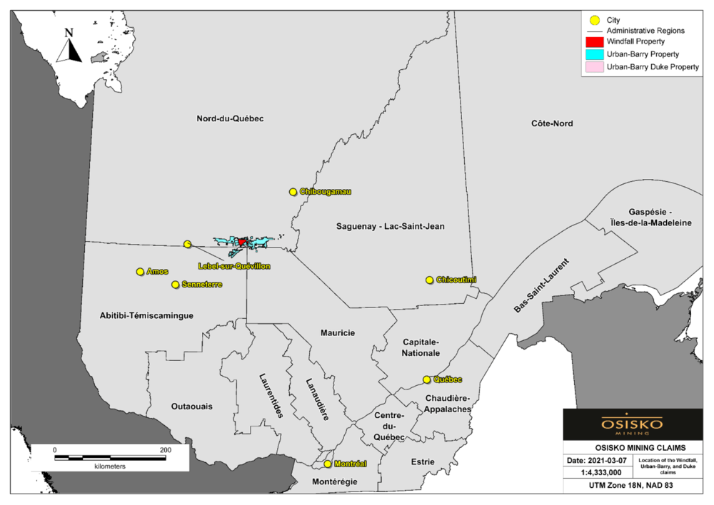
Figure 1: Location of the Quevillon gold project.

Figure 2: Regional geology of the Northern Volcanic Zone with and the locations of the Windfall, Urban-Barry and Quévillon projects.
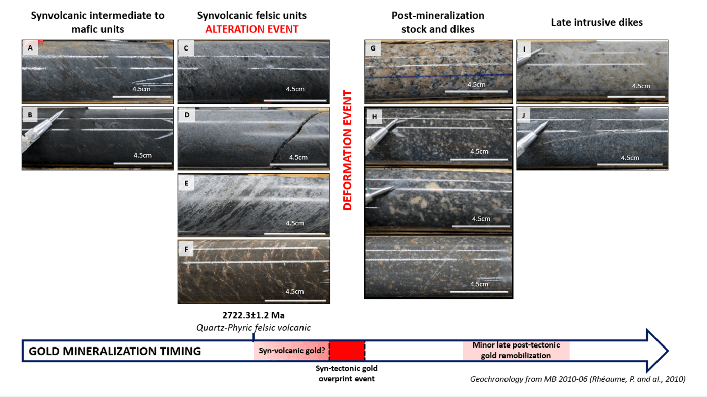
Figure 3: Types of rock encountered at the Osborne-Bell deposit according to the cross-cutting relationships. A) Moderately foliated volcaniclastic andesite displaying weak silicification accompanied by biotitization. B) Weakly foliated massive andesite. C) Weakly foliated quartz-phyric rhyodacite with moderate sericite-silica alteration. D) Unfoliated to weakly foliated aphyric rhyodacite displaying weak sericitization and silicification. E) Moderately foliated brecciated rhyodacite. F) “Zebra” rhyolite showing a dense stockwork of pale micro-cracks subparallel to the general foliation. G) Unfoliated and weakly hematized Beelher Stock. H) Three different facies of unfoliated feldspar-amphibole porphyry dikes. I) Unfoliated and fine-grained aplite dike. J) Unfoliated and fine-grained lamprophyre dike.

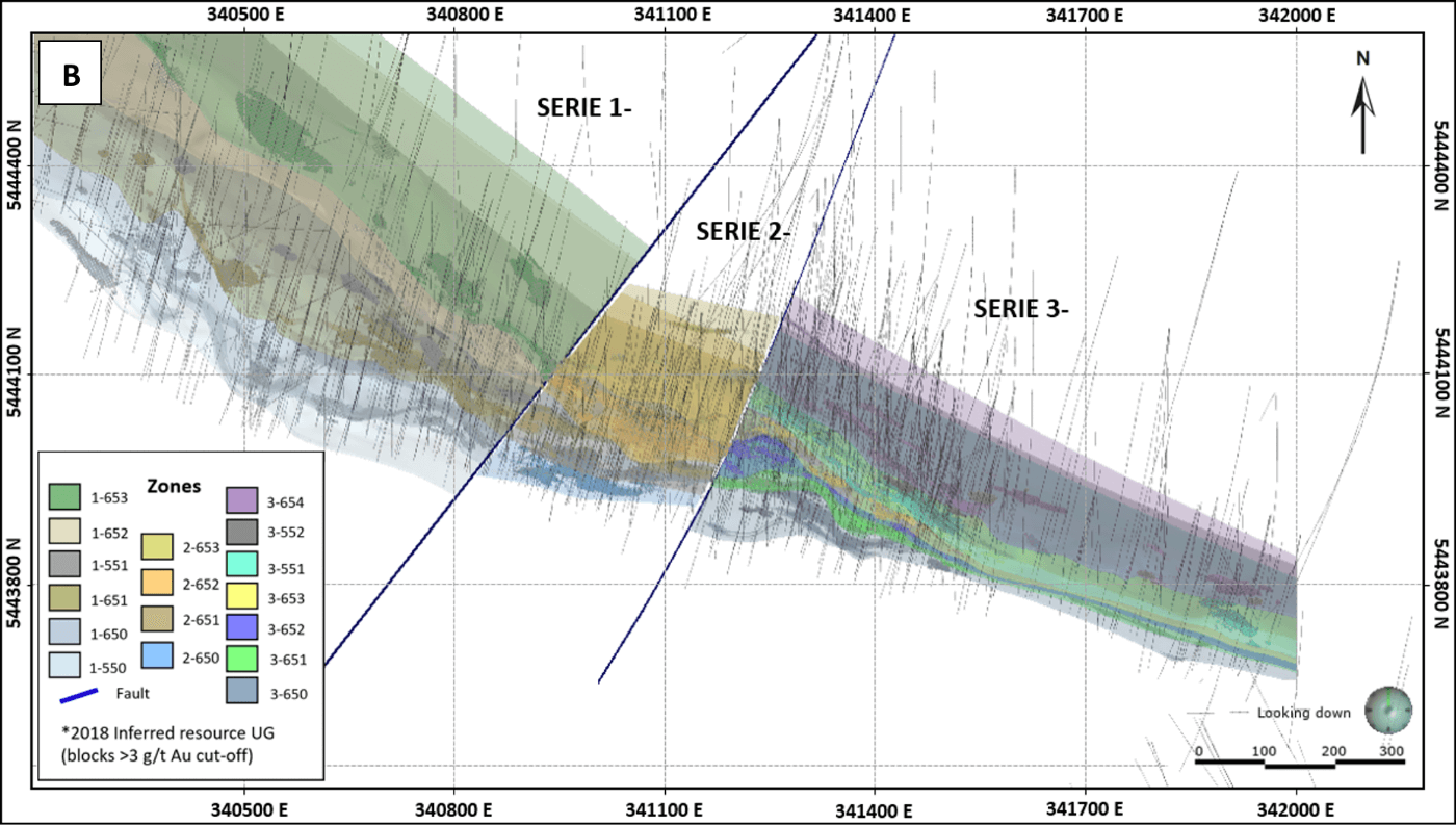
Figure 4: A) Longitudinal view (looking N345°) showing the 2018 Inferred Resources with a classification based on the modeled mineralized envelops, and B) Plan view of the modeled mineralized envelops superimposed on the 2018 Inferred Resources. All the drill hole traces are displayed in light grey.
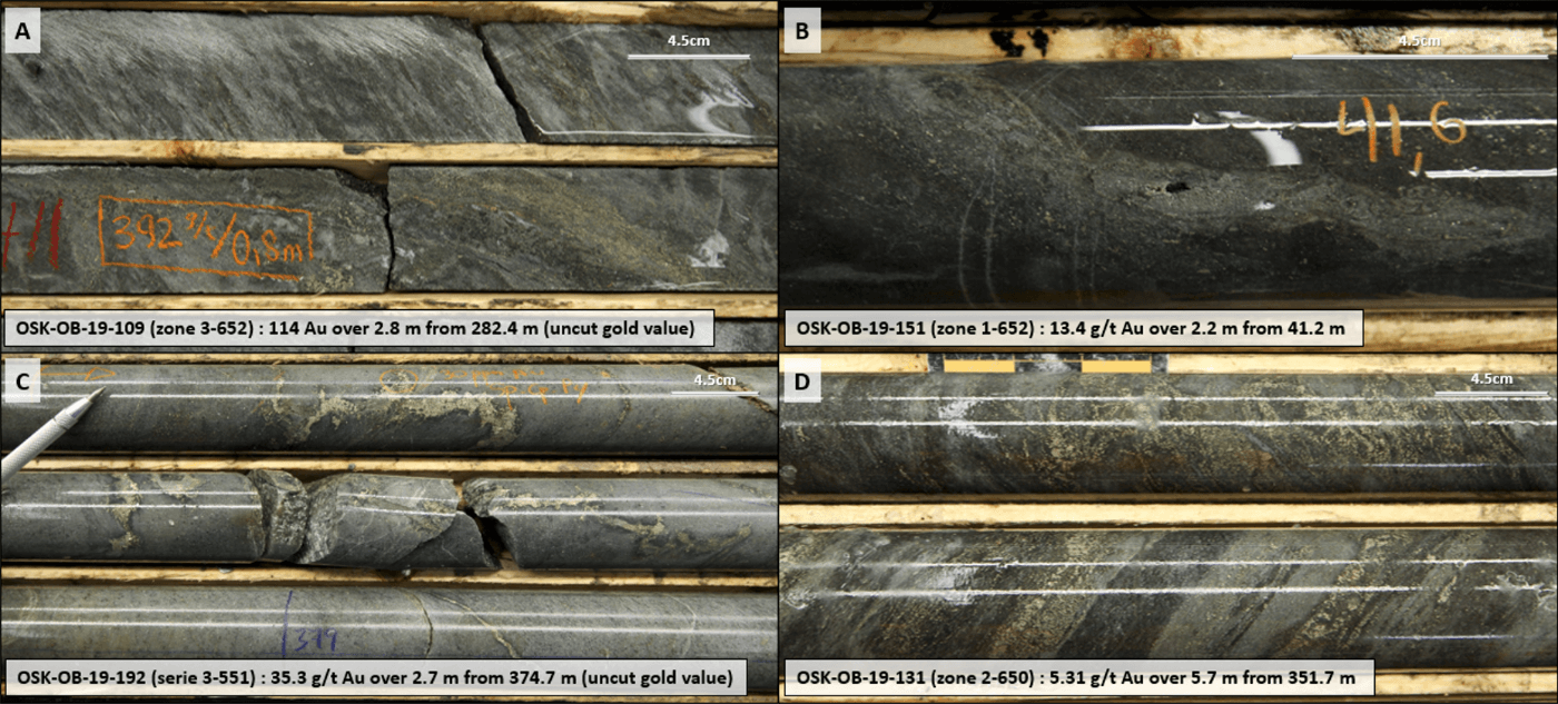
Figure 5: Mineralized textures encountered at Osborne-Bell deposit (from Osisko Mining 2019 definition drilling campaign). A) Moderately altered chlorite-biotite altered quartz-phyric rhyodacite hosting up to 5% disseminated pyrite and up to 15% pyrite±sphalerite concentrated within a centimetre-scale vein. Few specks of visible gold occur along the vein. B) Weakly biotite-sericite-chlorite altered andesite hosting 2% disseminated pyrite and chlorite-pyrite veinlets (CPV). Specks of gold is associated with the CPV. C) Moderately sericite-chlorite altered quartz-phyric rhyodacite hosting 6% pyrite, 2% chalcopyrite and traces of sphalerite within folded and low-angle chlorite-carbonate veinlets. D) Weakly sericite-silica-chlorite altered andesite hosting up to 15% pyrite and traces of sphalerite concentrated within centimetre-scale veinlets.


