Windfall
The Windfall property is 50% owned by Osisko Mining Inc. and consists of 286 individual claims covering an aggregate area of 12,523 hectares. The Windfall project, located in the Abitibi greenstone belt, Urban Township, Eeyou Istchee James Bay, Québec, Canada is 700 kilometres north-northwest of Montréal, 200 kilometres northeast of Val-d’Or and 115 kilometres east of Lebel-sur-Quévillon. The Windfall Project falls within the traditional territory of the Cree First Nation of Waswanipi.
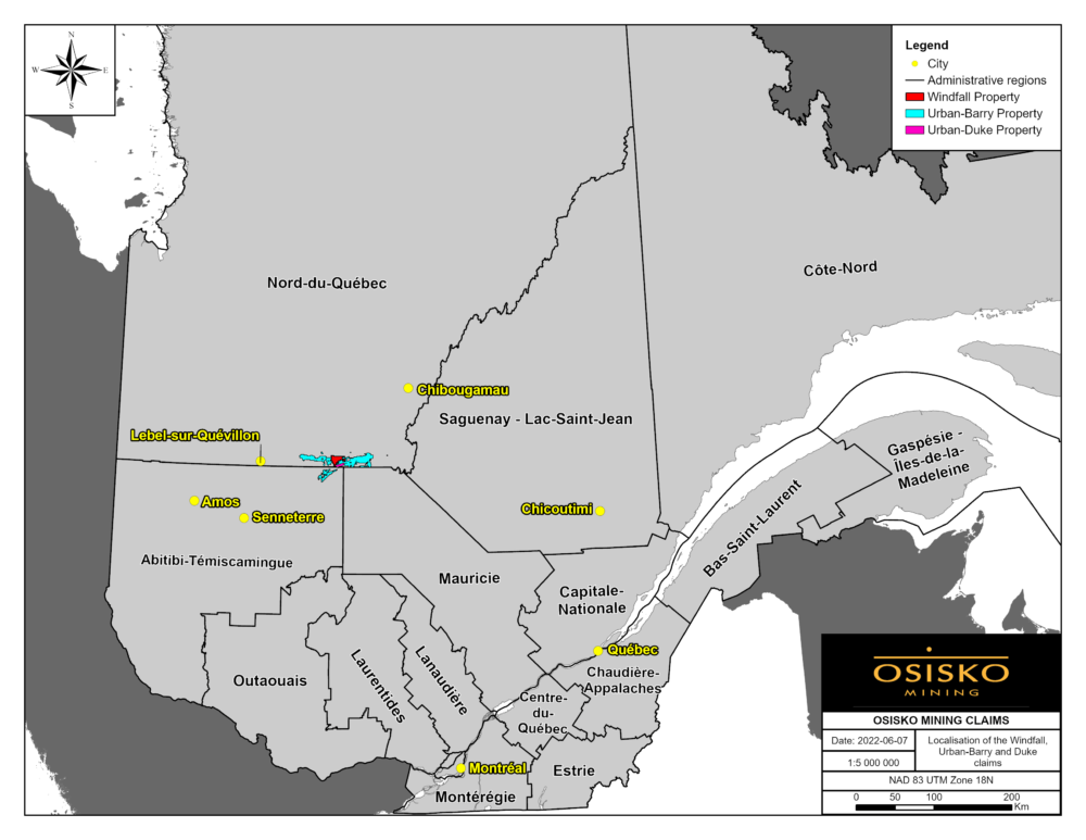
Figure 1: Map showing the location of the Windfall project.
Key Facts
Windfall is a world-class gold deposit located in the Eeyou-Itschee James Bay territory of Québec, Canada.
LATEST NEWS — WINDFALL
Press Release Maps
26/03/2019
Chargeability Signature Triple8 Area Southwest Plan View26/03/2019
Chargeability Signature Triple8 Area Southeast Longsection View26/03/2019
Chargeability Signature Triple8 Area South Inclined View26/03/2019
Chargeability Signature Triple8 Area Northeast Long-section View26/03/2019
Project Description
Geology
The Urban-Barry Greenstone Belt
The Windfall property is located in the central part of the Urban-Barry greenstone belt which is part of the Abitibi Subprovince (figure 2). The Urban-Barry belt is an east-west trending belt that is 135 kilometres long by 4 to 20 kilometres wide. The belt is dominated by mixed mafic to felsic volcanic rocks with lesser fine-grained clastic sedimentary sequences that are cross-cut by several east-trending and east-northeast trending shear zones. This greenstone belt was deformed during the 2.71 to 2.66 Ga Kenoran orogen (Card, 1990). The rocks are generally metamorphosed to greenschist grade metamorphism, but locally reach amphibolite facies within corridors of intense deformation and proximal to large pluton contacts (Joly, 1990).
The belt is divided into five rock formations constrained to 2791 Ma to 2707 Ma (Rhéaume and Bandyayera, 2006): 1) the Fecteau (2791 Ma), 2) the Lacroix (no age), 3) the Chanceux (2727 Ma), 4) the Macho (2717 Ma) and 5) the Urban (2714 to 2707 Ma). The Windfall deposit is hosted in the volcanic rocks of the Macho Formation that contains two distinct lithostratigraphic sequences: the Rouleau Member and the younger Windfall member (2716.9 ± 2 Ma). The Windfall deposit is hosted in the Windfall member which is comprised of: 1) calc-alkaline dacite, rhyodacite and trachyandesite, 2) tholeiitic felsic tuffs and lavas, 3) tholeiitic to transitional andesite porphyries and tuffs, and 4) minor iron formation (Bandyayera 2002, Rhéaume and Bandyayera, 2006). This volcano-sedimentary sequence is cut by a series of granodiorite quartz feldspar porphyry dikes (QFP). U-Pb zircon ages from pre- and post-mineralization QFP intrusions were dated at 2698 ±3 Ma and 2697.6 ±0.4 Ma, respectively (D. Davis unpublished report to Osisko Mining Inc. 2016).
Osisko mining is currently the largest stakeholder in the Urban-Barry greenstone belt with over 40 % of the land staked.
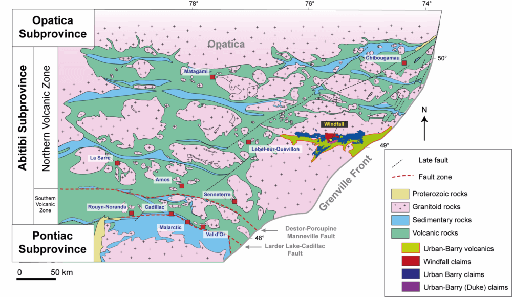
Figure 2: Simplified regional geology map showing the location of the Urban Barry greenstone belt.
Rock Types of the Windfall deposit
The rock types in the Windfall deposit are divided into two groups: 1) synvolcanic rocks that form part of the Macho Formation (ca. 2717 Ma), and 2) syntectonic rocks that intrude the volcanic sequence and are part of a regional tectonic-magmatic event at ca. 2698 Ma.
Synvolcanic Host Rocks
The intermediate to mafic volcanic rocks are of tholeiitic affinity and range in composition from basalt to andesite. They consist of massive, pillowed, fragmental and breccia flows that are locally vesicular or porphyritic with phenocrysts of plagioclase. The rock is commonly fine-grained, medium green to dark green in colour, and is weakly to strongly foliated.
The felsic volcanic rocks are of tholeiitic affinity and range in composition from dacite to rhyolite. Texturally, they consist of massive and breccia flows that are often porphyritic containing small (1 to 3 millimetres) quartz phenocrysts that vary in abundance from 2 to 10%. The rock is commonly fine-grained, yellowish beige in colour that can locally be green when chloritized and is weakly to moderately foliated. Felsic volcanics are stratigraphically located above the mafic-intermediate volcanics.
Mafic intrusions are of tholeiitic affinity and range in composition from basalt to komatiite but are simply visually described as gabbros. These intrusions locally cross-cut the mafic to felsic volcanic rocks, but mainly occur as sill shaped bodies that are laterally extensive and range from 1 to 300 m in thickness. The rocks are texturally homogenous and massive, have a medium to dark green color, are fine- to medium-grained and are locally weakly foliated.
At depth, thin horizons (0.3-1m) of argillite and mudstone are locally interbedded within the felsic volcanic sequence. The sedimentary units are dark grey-green, fine-grained, bedded, and contain pyrite-pyrrhotite laminations.
Windfall Intrusive Complex
In the Windfall deposit, five texturally distinct QFP dikes are observed to cross-cut the volcanic strata at high angles. The QFP dikes are all of granodiorite composition and of calc-alkaline affinity. The dikes are divided into three main groups based on several criteria: texture, colour, size and abundance of quartz phenocrysts, orientation and timing with respect to deformation and mineralization. These groups are: 1) pre-mineral fragmental and small quartz eye QFPs, 2) spre-mineral large quartz eye QFPs; and 3) post-mineral hematite altered QFPs.
Pre-mineral fragmental and small quartz eyes QFPs
The small quartz eye QFP dike is characterized by 2 to 10% small quartz eyes generally less than 2 millimetres in diameter (figure 3 – I2P). This unit has some textural variations that range from massive and porphyritic to fragmental with up to 30% sub-angular to sub-rounded fragments. The fragments are generally <1 centimetre in diameter. Fragments are comprised of volcanic fragments, both intermediate and felsic compositions, that are locally sericite and pyrite altered. This dike is the earliest observed intrusive phase and was dated at 2698 ± 3 Ma using TIMS U-Pb of zircon (D. Davis, 2016, unpublished report to Osisko Mining).
In the Lynx zone, another fragmental intrusive phase is present and referred to as the I1 Frag. The I1 Frag differentiates from the I2P as it contains abundant fragments of: 1) earlier QFP intrusive; 2) felsic and mafic volcanics; 3) tourmaline-breccia; and 4) quartz-pyrite fragments.
Pre-mineral large quartz eyes QFPs
The large quartz eyes QFP dikes form stocks of sub-vertical dikes that range in orientation from north to east-northeast and crosscut the earlier fragmental and small quartz eye porphyries. They are composed of an aphanitic matrix that contains variable proportions of large sub-rounded quartz eyes (> 2 mm) and locally altered feldspar and amphiboles phenocrysts. The dikes are classified according to the abundance of quartz eyes which varies from trace <1% (I1P Try), 1 to 10% (I1P YL), and >10% (I1P YB) large quartz eyes as shown in figure 3.
Post-mineral hematite altered QFPs
There are two types of post-mineral hematite altered QFPs and they are both geochemically indistinguishable from each other (figure 3 – Red Dog and I13). The Red Dog intrusion has a brick-red color, an aphanitic matrix that contains 3 to 10% quartz phenocrysts (up to 1 cm) and 5 to 10% poorly defined relict feldspar phenocrysts. Locally the Red Dog intrusion is weakly magnetic, which is caused by millimetre-sized magnetite crystals. The Red Dog intrusion was dated at 2697 ± 0.4 Ma using TIMS U-Pb of zircon (D. Davis, 2016, unpublished report to Osisko Mining). The I13 intrusion is pinkish to slightly orange, fine grained with a saccharoidal-texture, is homogeneous, non-magnetic, and contains less than 1% quartz eyes smaller than 2 millimetres. The I13 intrusion was dated at 2695 ± 3.8 Ma using HR-ICP-MS U-Pb of zircon (C. Azevedo, 2018, unpublished data).
The post-mineral dikes are a late intrusive phase that cross-cut all the volcanics, syn-deformation QFP units, and gold mineralization and associated hydrothermal alteration as observed in surface and underground exposures.
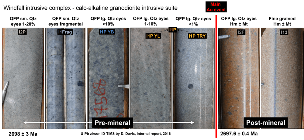
Figure 3: Representative photographs of pre-mineral QFP intrusive rocks from the Windfall intrusive complex in order from earliest to the latest. Dating of the I2P and of the Red Dog dike were done using TIMS U-Pb of zircon by D. Davis at the University of Toronto (unpublished data).
Feasibility Study
November 28, 2022 Feasibility Study (1-6)
• Full year average production of 306,000 oz Au, 8.1 g/t Au average grade fully diluted
• Peak production of 374,000 oz Au in year two
• Average after-tax free cash flow of C$257 Million per full year of production (C$2.3 Billion cumulative free cash flow)
• Capex of US$607 Million (includes US$38 Million as contingency in direct and indirect costs), NPV/Capex ratio of 1.5
• All-in sustaining cost (“AISC”) of US$758/oz; Cash cost of US$587/oz
• 3,400 tonne per day milling operation
• Average recovery of 93%; all in mining cost of US$136/tonne
• C$6.2 Billion of gross revenue
· Creation of over 1,000 direct and indirect jobs during construction and over 670 direct permanent jobs during operation
Notes:
(1) Cautionary Statement: Readers are advised that the FS summarized above is intended to provide only an initial, high-level overview of the project potential and design options. The FS mine plan and economic model include numerous assumptions. There is no guarantee the project economics described herein will be achieved.
(2) Full years of production refer to Years 1 to 9.
(3) AISC is presented within the meaning defined by the World Gold Council (“WGC”),less corporate G&A.
(4) The FS relating to the disclosure in this news release will be filed on SEDAR (www.sedar.com) under Osisko’s issuer profile within 45-days.
(5) Total cash costs and cash costs per ounce, and AISC and AISC per ounce are non-IFRS financial measures. See “Non-IFRS Financial Measures” for a discussion of non-IFRS financial measures.
(6) References to C$ and US$ are to Canadian and United States dollars, respectively.
Table 1: FS Summary
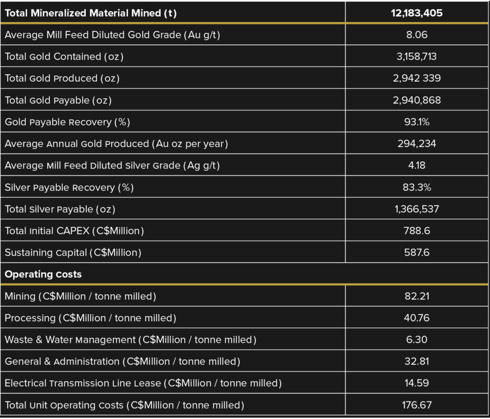
Table 2: Summary Economics at US$1,600 Au
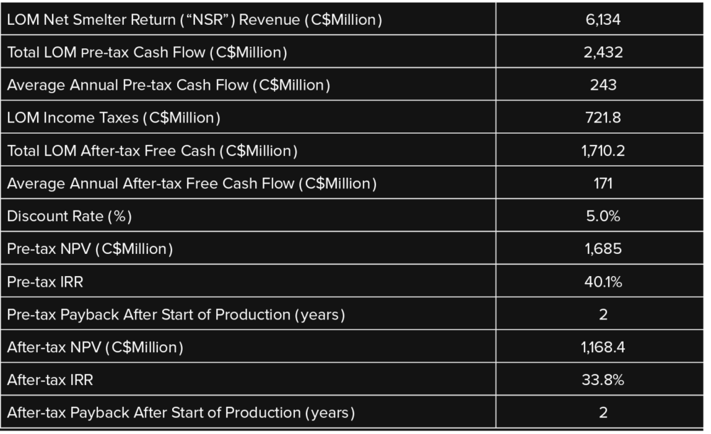
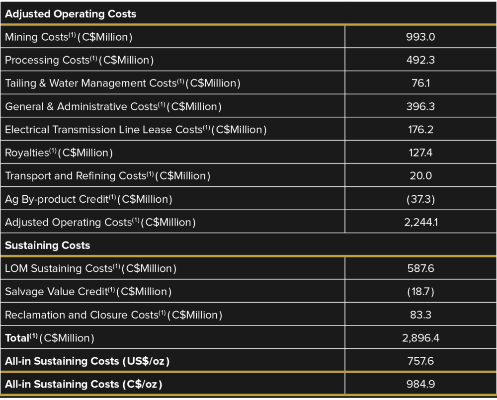
Table 3: All-in Sustaining Cost
Notes:
1) All-in sustaining costs are presented as defines by the WGC less corporate G&A
2) Millions of Canadian dollars
Table 4: Gold Price(1) and Exchange Rate(2) Sensivity
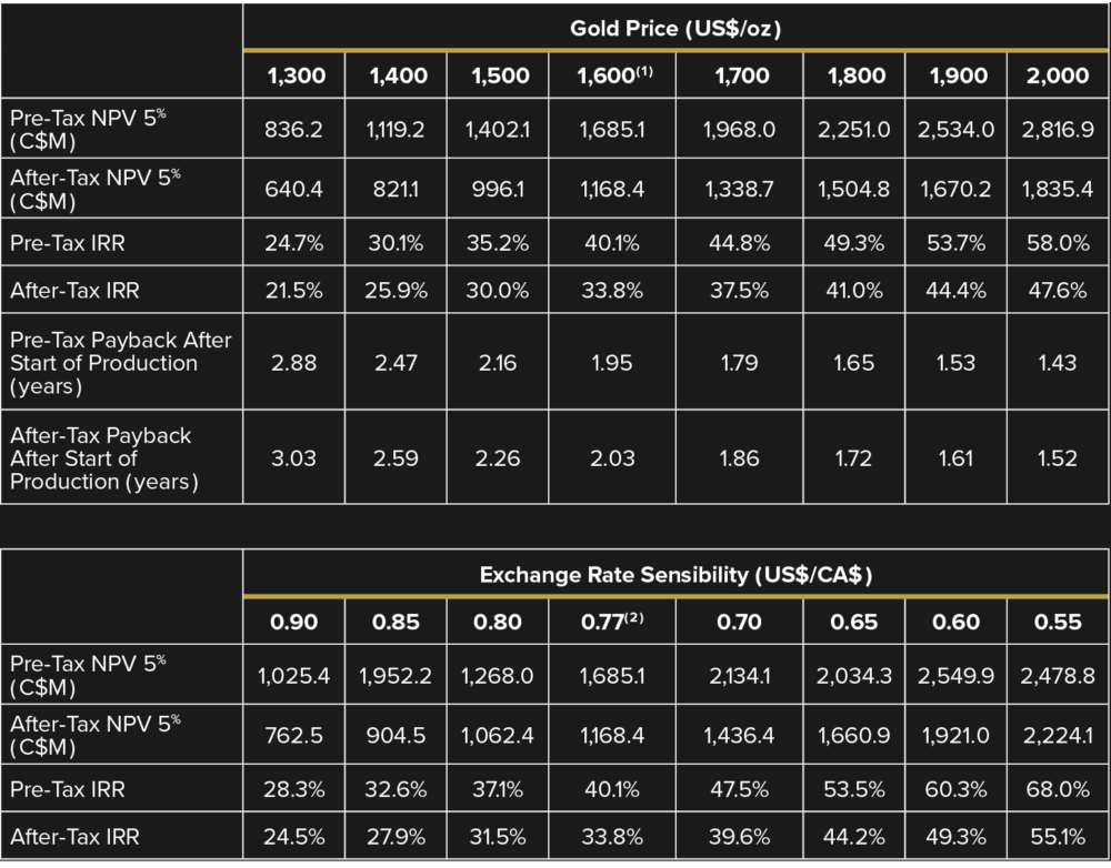
Notes:
1. The base case uses a gold price of US$1,600/oz.
2. The base case uses an exchange rate of US$1.00=C$1.30 (orUS$0.77 = C$1.00)
Table 5: Capital Cost Summary
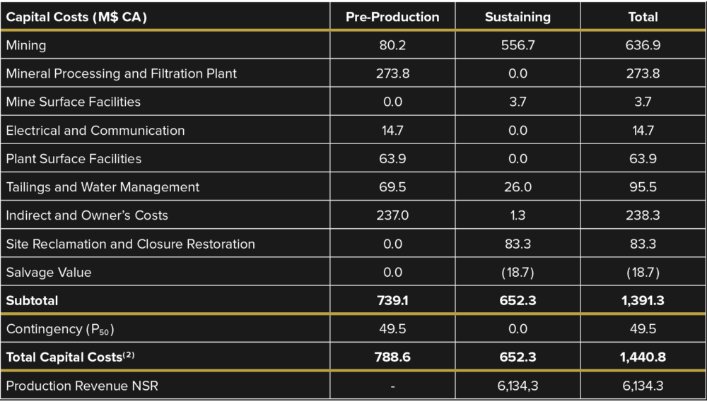
Notes:
1. Totals may differ due to rounding
2. Total capital costs exclude: (i) sunk costs for pre-ordered grinding mills (C$5.6 million) and EIA (C$1.1 million); (ii) long-lead items, including engineering studies (C$34.6 million), logistics and warehousing (C$2.1 million), mechanical and electrical packages (C$57.0 million), camp (C$32.2 million), material opportunity purchase (C$8 milliion), mining fixed equipment (C$2.9 million) and contingency (C$3.0 million).
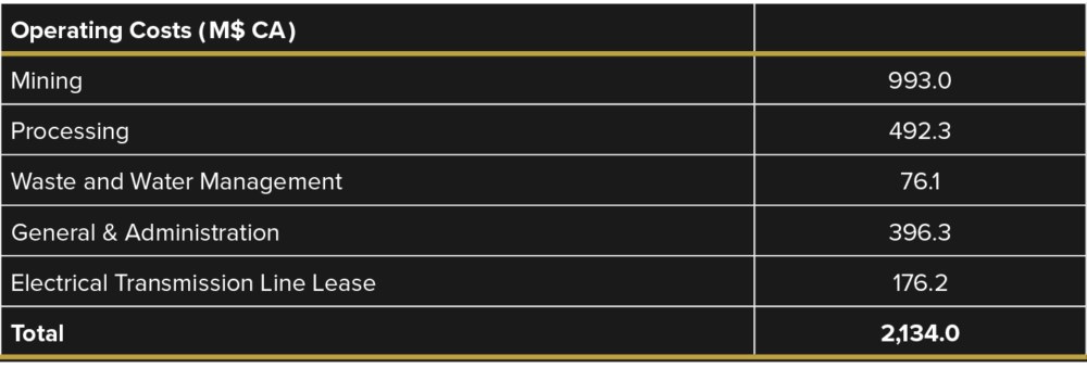
Table 6: Operating Cost Summary
Gold Mineralization
Gold Mineralization
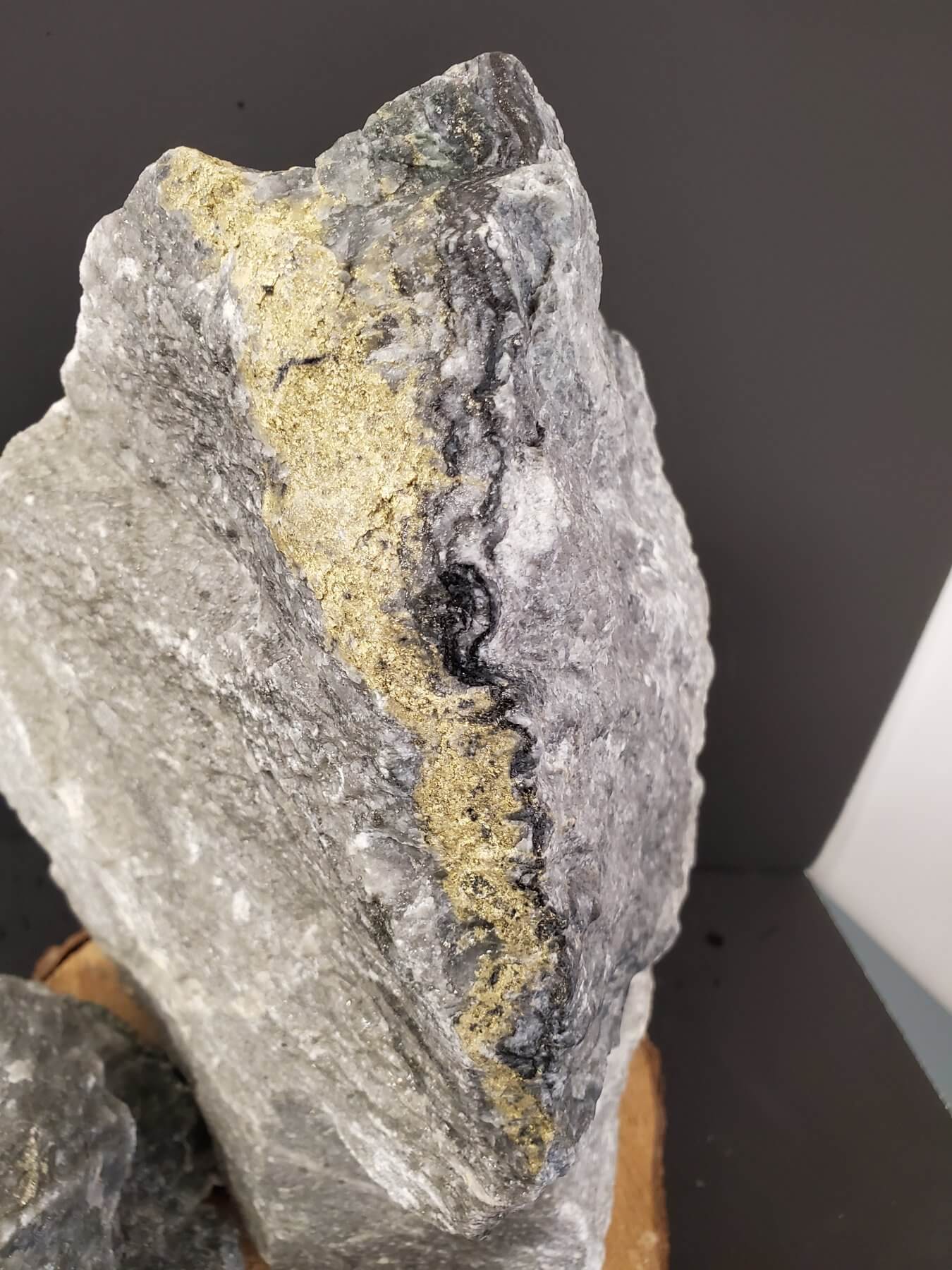
Two dominant styles of gold mineralization are observed in the Windfall deposit: 1) vein-type mineralization, and 2) replacement-type mineralization. Vein-type mineralization consists of grey to translucent coloured quartz veins that contain subordinate amounts of ankerite, tourmaline, pyrite and commonly visible gold (figure 4). The veins have sharp contact margins that are straight or folded. Texturally these veins are massive, vary in thickness from 0.1 m to 1 m, and are generally associated with the highest gold grades ranging on average from 20 g/t to >100 g/t). In the veins, sulphide content ranges from 1 to 80% and is dominated by pyrite with minor concentrations (<1% total sulphide) of chalcopyrite, sphalerite, arsenopyrite, galena, pyrrhotite, tennantite and other Bi-Te minerals, as identified by internal petrographic and microanalytical analyses. This mineralization style is the dominant ore-type in felsic volcanic and intrusive domains of the deposit (i.e., Caribou, Underdog and Lynx). Replacement-type mineralization occurs at the margins of vein-type mineralization or highly altered zone that lack the development of quartz veins. This mineralization style consists of corridors of pyrite replacement zones and stockworks associated with a strong pervasive silica-sericite-ankerite ± tourmaline alteration of the host rock (figure 4). The gangue and ore related -metals are identical to those mentioned above in the vein-type mineralization. The gold is associated with disseminated pyrite, which varies from 1 to 80% over mineralized intervals. This mineralization style is commonly observed to occur in the mafic volcanic dominated domains of the deposit (i.e., Zone 27, Triple 8).
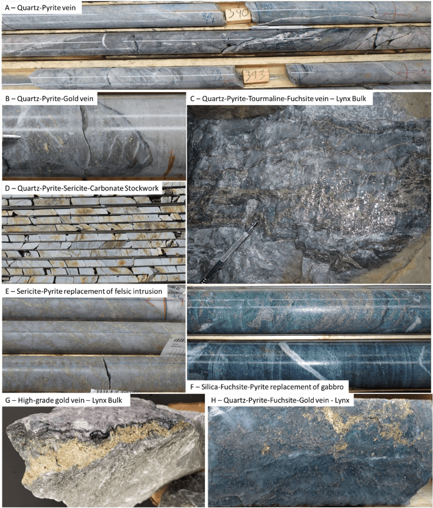
Figure 4: Representative photographs of significant gold mineralisation styles in the Windfall deposit.
Mineral Zones
The most significant gold mineralization defined to date is currently known for lateral extent of 3,000 m and a confident vertical extent of approximately 1,600 metres. It is separated into four areas; the Lynx area (Lynx Main, Lynx HW, Lynx SW, Triple Lynx, and Lynx 4), the Main area (Zone 27, Caribou 1, Caribou 2, Caribou Extension, Bobcat, Mallard, Windfall North and F-Zones), the Underdog area, and the Triple 8 area (figure 5). In general, the bulk of the gold mineralization in the Windfall deposit forms within a series of subvertical to moderately dipping zones that have sigmoidal geometries with true widths of single mineralized envelopes averaging between 1-10 m and are generally oriented east-northeast with plunges of about 35° towards the east-northeast.
The size and nature (i.e., vein- and replacement-type mineralization) of the mineralized lenses vary slightly from area to area and this reflects the different host rock types across the deposit. The main differences between the host rock types are the different rheological and chemical contrasts which create the necessary traps to channel and destabilize gold-rich fluids.
Mineral Reserve & Resource Estimate
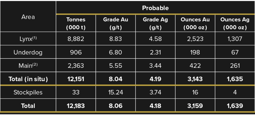
Mineral Reserve Estimate
Table 1: Windfall Mineral Reserve
(1) Lynx area includes: Lynx Main, Lynx HW, Lynx SW, Lynx 4, and Triple Lynx.
(2) Main area includes: Zone 27, Caribou 1, Caribou 2, Caribou Extension, Bobcat, Mallard, Windfall North, and F-Zones.
Notes:
- The independent qualified person for the 2022 Mineral Reserve Estimate, as defined by NI 43-101 guidelines, is Patrick Langlais, P. Eng. (OIQ#6021556), of Entech Mining Ltd. The effective date of the estimate is November 25, 2022.
- The Windfall Mineral Reserve Estimate follows the May 19, 2014 “CIM Definition Standards – For Mineral Resources and Mineral Reserves” and the November 29, 2019 “CIM Estimation of Mineral Resources and Mineral Reserves Best Practice Guidelines”.
- These Mineral Reserves have been diluted based on geotechnical recommendations and have had a mining recovery applied.
- Values are rounded to nearest thousand, which may result in apparent discrepancies.
- The Mineral Reserve is depleted for all mining to November 3, 2022.
- The Mineral Reserve is reported using a 3.5-g/t break-even, a 2.5-g/t stope incremental, and a 1.7-g/t marginal cut-off grade.
- All Measured Mineral Resources have been classified as Probable Mineral Reserve.
- Stockpile values were provided by Osisko and account for less than 0.11% of Mineral Reserve ounces.
- Estimates use metric units (metres (m), tonnes (t), and g/t). Metal contents are presented in troy ounces (metric tonne x grade / 31.103475).
- The independent qualified person is not aware of any known environmental, permitting, legal, title-related, taxation, socio-political or marketing issues, or any other relevant issue that could materially affect the Mineral Reserve Estimate.
June 2022 Mineral Resource Estimate Update
- Measured and Indicated Resources (M&I): 4.1M oz Au at 11.4 g/t Au;
- Inferred Resource: 3.3M oz Au à 8.4 g/t Au;
- The resources are defined from surface to a depth of 1,600 metres. The resources excluding the deeper zone Triple 8 (T8) are defined from surface to a depth of 1200 metres.
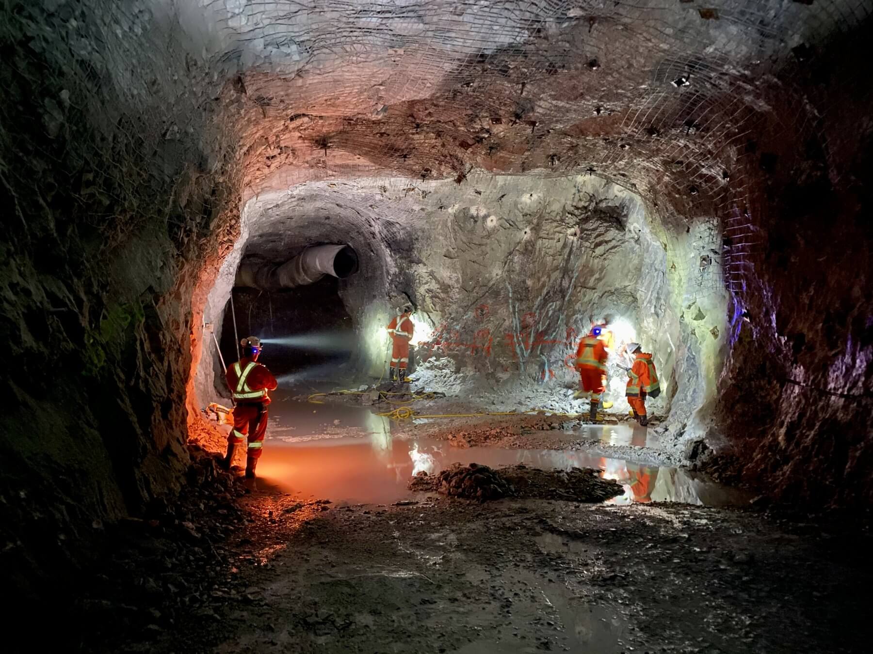
The 2022 drilling increased the measured and indicated mineral resource estimate by 26% (adding 846,000 ounces) with average grade increased by 8%. In addition to the two bulk samples (Zone 27 and Lynx) that have been successfully completed in 2018 and 2019 the exploration ramp access is currently at >635 m vertical depth in Lynx.
Table 2: Windfall Gold Deposit Measured, Indicated, and Inferred Mineral Resource Estimate (inclusive of Mineral Reserve) by Area (3.5 g/t Au cut-off)

Notes:
- Values are rounded to nearest thousand which may cause apparent discrepancies.
- Lynx area includes: Lynx Main, Lynx HW, Lynx SW and Lynx 4 and Triple Lynx.
- Main area includes: Zone 27, Caribou 1 & 2, Caribou Extension, Bobcat, Mallard, Windfall North, and F-Zones.
- Cut-off grade is not applicable to the stockpiles. See Windfall Gold Deposit Mineral Resource Estimate notes further below.
Table 3: Windfall Project Measured, Indicated, and Inferred Mineral Resource Sensitivity Table

Notes:
- Values are rounded to nearest thousand which may cause apparent discrepancies.
- MRE cut-off: 3.5 g/t Au
- The cut-off grade variation is not applicable to the material in the Stockpiles.
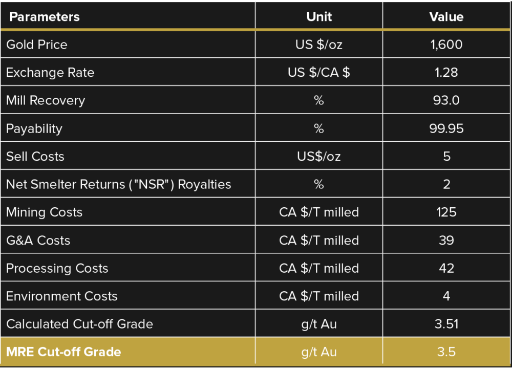
Table 4: Parameters used to estimate the underground cut-off grade for the Windfall Gold Deposit Mineral Resource Estimation
Windfall Gold Deposit Mineral Resource Estimate Notes:
- The independent qualified person for the 2022 MRE, as defined by NI 43-101 guidelines, is Pierre-Luc Richard, P. Geo. (OGQ#1119), of PLR Resources Inc. The effective date of the estimate is June 07, 2022.
- The Windfall mineral resource estimate follows the November 29, 2019, CIM Estimation of Mineral Resources and Mineral Reserves Best Practice Guidelines.
- These mineral resources are not mineral reserves as they have not demonstrated economic viability. The quantity and grade of reported Inferred mineral resources in this news release are uncertain in nature and there has been insufficient exploration to define these resources as Indicated or Measured; however, it is reasonably expected that the majority of Inferred mineral resources could be upgraded to Indicated mineral resources with continued exploration. Resources are presented undiluted and in situ and are considered to have reasonable prospects for economic extraction. Isolated and discontinuous blocks above the stated cut-off grade are excluded from the mineral resource estimate. Must-take material, i.e., isolated blocks below cut-off grade located within a potentially mineable volume, was included in the mineral resource estimate.
- Mineral Resources are reported inclusive of those Mineral Resources converted to Mineral Reserves.
- As of June 07, 2022, the database comprises a total of 4,834 drill holes for 1,852,861 m of drilling in the area extent of the mineral resource estimate, of which 4,152 drill holes (1,665,282 m) were completed and assayed by Osisko. The drill hole grid spacing is approximately 12.5 m x 12.5 m for definition drilling, 25 m x 25 m for infill drilling and larger for extension drilling.
- All core assays reported by Osisko were obtained by analytical methods described below under “Quality Control and Reporting Protocols”.
- Geological interpretation of the deposit is based on lithologies, mineralization style, alteration, and structural features. Most mineralization envelopes are subvertical, striking NE-SW and plunging approximately 40 degrees towards the North-East. The 3D wireframing was generated in Leapfrog Geo, a modelling software, from hand selections of mineralization intervals. The mineral resource estimate includes a total of 579 tabular, mostly sub-vertical domains defined by individual wireframes with a minimum true thickness of 2.0 m.
- Assays were composited within the mineralization domains into 2.0 m length composites. A value of 0.00125 g/t Au and 0.0025 g/t Ag (¼ of the detection limit) was applied to unassayed core intervals.
- High-grade composites were capped. Capping was determined in each zone from statistical studies on groups of lenses sharing similar mineralization characteristics. Capping varies from 6 g/t Au to 200 g/t Au and from 5 g/t Ag to 150 g/t Ag. A three-pass capping strategy defined by capping values decreasing as interpolation search distances increase was used during grade estimation.
- Block models were produced using Datamine™ Studio RM Software. The models are defined by parent cell sizes of 5 m EW, 2 m NS and 5 m height, and sub-blocked to minimum sub-cell sizes of 1.25 m EW, 0.5 m NS and 1.25 m height.
- Ordinary Kriging (OK) based interpolations were produced for gold estimations in each zone of the Windfall deposit, while silver grade estimations were produced using Inverse Distance Squared (ID2) interpolations. Gold estimation parameters are based on composite variography analyses. The gold estimation parameters were used for the silver estimation.
- Density values between 2.74 and 2.93 were applied to the mineralized lenses.
- The Windfall mineral resource estimate is categorized as Measured, Indicated, and Inferred mineral resource as follows:
- The Measured mineral resource category is manually defined and encloses areas where:
- drill spacing is less than 12.5 m;
- block are informed by mostly four drill holes;
- geological evidence is sufficient to confirm geological and grade continuity;
- lenses have generally been accessed by underground workings.
- The Indicated mineral resource category is manually defined and encloses areas where:
- drill spacing is generally less than 25 m;
- blocks are informed by mostly three drill holes;
- geological evidence is sufficient to assume geological and grade continuity.
- The Inferred mineral resource category is manually defined and encloses areas where
- drill spacing is less than 100 m
- blocks are informed by a minimum of two drill holes;
- geological evidence is sufficient to imply, but not verify geological and grade continuity.
- The Measured mineral resource category is manually defined and encloses areas where:
- Tonnage and gold grade of the stockpiles were estimated using the grade control model. Densities by lithologies, ranging from 2.76 to 2.84, were used in the estimation of the tonnages. Gold grades were estimated using muck samples weighted average results for every round tonnage, based on muck samples with an average sample weight of 3.4 kg taken every 8-yard scoop bucket. The sampling capping varying between 60 g/t Au to 80 g/t Au was applied on the muck gold grade results. An average per silver grade in the stockpiles was reported from the resource block model as silver was not analyzed in the muck samples.
- The mineral resource is reported at 3.5 g/t Au cut-off. The cut-off grade is based on the following economic parameters: gold price at 1,600 USD/oz, exchange rate at 1.28 USD/CAD, 93.0% mill recovery; payability of 99.95%; selling cost at 5 USD/oz, 2% NSR royalties, mining cost at 125 CAD/t milled, G&A cost at 39 CAD/t milled, processing cost at 42 CAD/t, and environment cost at 4 CAD/t.
- Estimates use metric units (metres (m), tonnes (t), and g/t). Metal contents are presented in troy ounces (metric tonne x grade / 31.103475).
- The independent qualified person is not aware of any known environmental, permitting, legal, title-related, taxation, socio-political or marketing issues, or any other relevant issue, that could materially affect the mineral resource estimate.
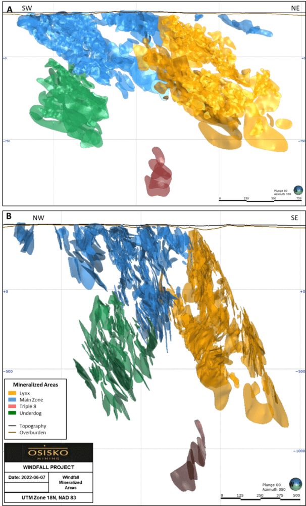
Figure 5: Mineralized domains modelled in the Windfall deposit A) Longitudinal view (looking northwest); and B) Cross-section view (looking northeast). Source: Osisko, 2022.
Lynx
The Lynx area consists of five gold mineralized zones located in the east-northeast portion of the deposit (Figure 6). Most of the Lynx mineral zones form an extensive anastomosed network of quartz-pyrite veins (i.e., vein-type mineralization) and associated sericite-silica-pyrite replacement zones that occur in proximity to a swarm of large quartz eye QFP intrusions that intrude a thick sequence of felsic volcanics and gabbro intrusions. The Lynx area is located in the hinge and along the southern limb of an open fold plunging at 40º towards the east-northeast along the Bank fault-shear zone. The Lynx Main, Lynx HW, Lynx SW and Lynx 4 zones are closest to the Bank fault and are locally deformed by the latter. In contrast, the Triple Lynx zone is located roughly 200 m to 300 m lateral distance from this structure and occurs beneath a thick gabbro intrusion
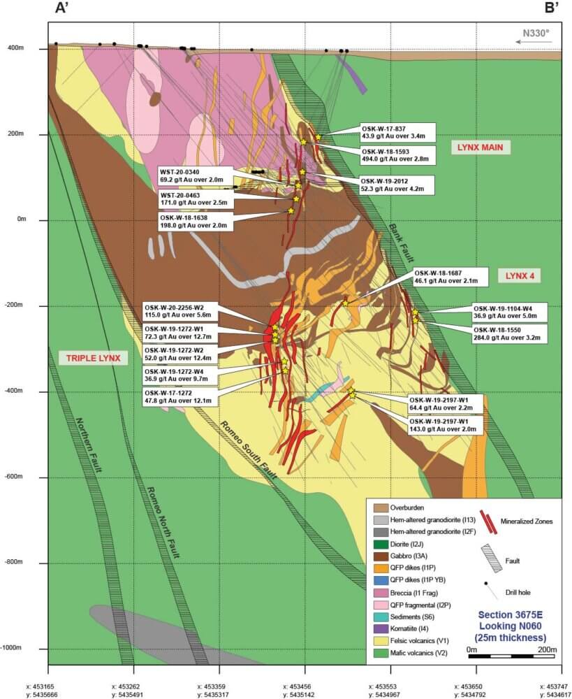
Figure 6: Cross-section of the Lynx area.
Main
The Main area consists of six gold mineralized zones located in the central portion of the deposit (Figure 7). Gold mineralization is located along the contacts of east-northeast trending narrow subvertical pre-mineral QFP dikes within a package of felsic to mafic volcanic rocks. Most mineral lenses in the Main area are associated with a replacement-type mineralization occurring near contacts between volcanic rocks and pre-mineral QFP dikes. For Zone 27, gold mineralization is hosted proximal to the contacts between basalt-andesites and the pre-mineral large quartz eye QFP dikes, whereas in the Caribou zone it is mostly hosted at the contacts between felsic volcanics and pre-mineral large quartz eye QFP dikes. The Main area terminates at the upper contact of the thick post-mineral Red Dog intrusion.
Underdog
The Underdog area is located in the southwestern portion of the deposit and is separated from the Main area by the post-mineral Red Dog intrusion (Figure 7). The gold mineralization is hosted in a large stock composed of three phases of pre-mineral QFP intrusions and locally in the surrounding host mafic-intermediate volcanic rocks. The mineralization in the Underdog area is similar to that observed in the Lynx zone and is composed of an extensive anastomosed network of quartz-pyrite veins hosted in strongly sericitized and silicified pre-mineral QFP intrusions. Mineralization is commonly located along the contacts of the various pre-mineral QFP intrusive phases. The top of this deeper mineral zone starts at around 600 m depth and continues to depths of roughly 1,600 m where it is still open at depth and down-plunge.
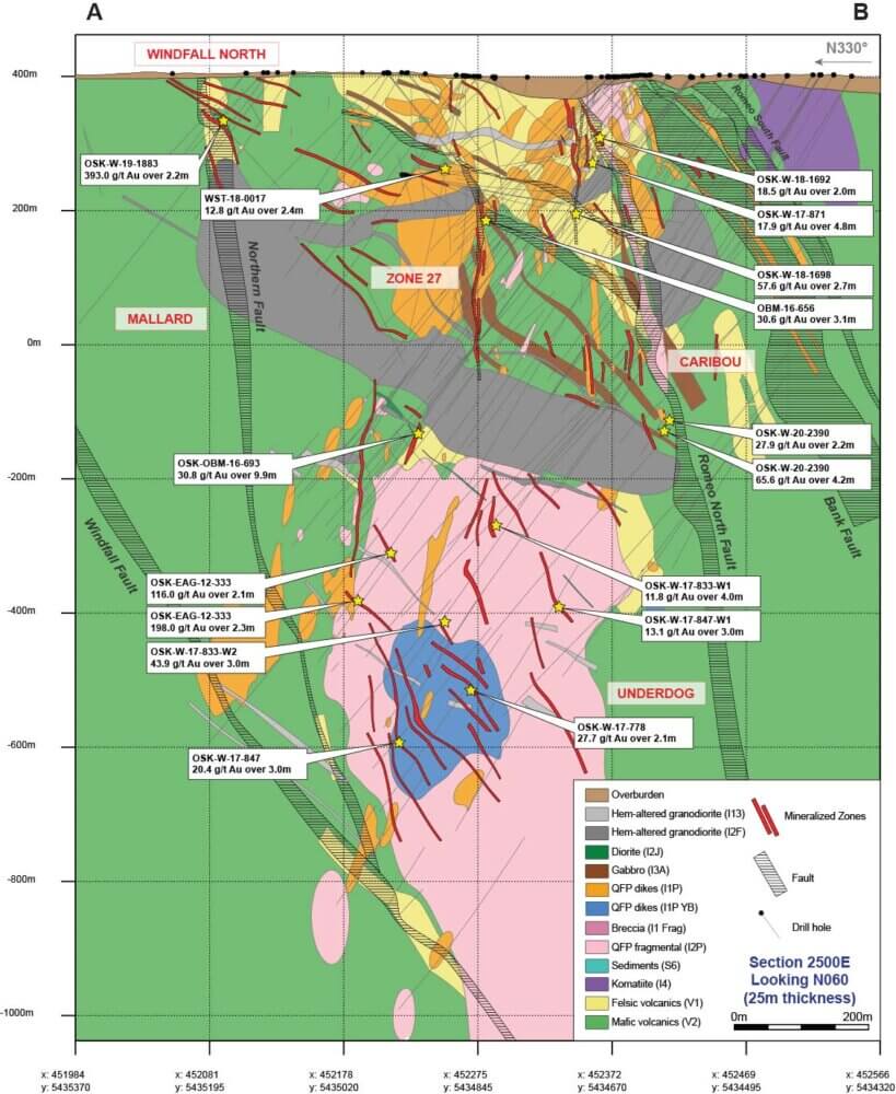
Figure 7: Cross-section of the Main and Underdog sectors.
Triple 8
The Triple 8 zone is located 660 m east-northeast from the closest mineralized intercept in the Underdog Zone. The drill hole Deep Discovery 1, the longest diamond drill hole in Canada with a final depth of 3,467 m, also intercepted the Triple 8 corridor and several other zones of anomalous gold mineralization up to 116 m in strike length. The Triple 8 zone consists of mostly mafic to intermediate volcanic rocks intercalated with felsic flows and gabbro sills cross-cut by a series of syn-deformation QFP intrusions and post-mineral Red Dog intrusion. The volcanic package is metamorphosed to upper greenschist facies consisting of a chlorite-calcite-epidote-magnetite metamorphic assemblage. This alteration assemblage is then cross-cut by shear zones altered by a gold-bearing fluid, forming an early biotite-chlorite-carbonate-pyrite assemblage that is later overprinted by a sericite-carbonate-silica-pyrite assemblage. The latter alteration assemblage is associated with most of the gold mineralization. The primary control on gold mineralization in the Triple 8 area appears to be controlled by series of stacked northeast-oriented shear zones. Within these shear zones, the mineralization is mainly composed of pyrite-rich replacement zones that are cross-cut by laminated quartz-carbonate-tourmaline ± pyrite veins and carbonate-quartz stockworks and breccias.
F-Zones
The F-Zones and the Windfall North zone are located in the northern portion of the deposit. Gold mineralization in the F-17, F-11, F-51 and the Windfall North zones trend to the northeast, subparallel to the lens in the Main area, but dip steeply to the northwest. Windfall North, F-17 and F-51 are aligned along the same trend, whereas the F-11 zone is located 500 m to the northwest. The mineralization in these zones is similar to the replacement-type mineralization observed in other parts of the deposit and the zones are located proximal to the contacts between basalt and pre-mineral large quartz eye QFP dikes.
Deposit Type
The Windfall deposit is classified as a pre-Temiskaming intrusion-associated gold deposit due to:
1) a temporal and spatial association of gold with felsic calc-alkaline QFP intrusions; and 2) the main gold event (i.e., vein- and replacement-type mineralization) being interpreted to pre-date known regional scale deformation. Gold mineralization is structurally controlled and is hosted in:
1) a series of extensional faults and fractures that are concentrated in areas of contrasting competencies, often located proximal to the contacts between pre-mineral QFPs and host volcanic rocks; 2) along boundaries between flat-lying lithologies and steeper structures; and 3) along boundaries of chemical contrast between ultramafic-mafic and felsic rock types. The mineralization style is variable (i.e., vein- to replacement-type) and is largely dependent on host rock composition. Mineralization consists of a network of quartz-pyrite veins and an associated silica-sericite-pyrite alteration assemblage. The mineralization and alteration have strike lengths of >2 km that show, as of yet, no recognized vertical zoning. The QFP intrusions were emplaced as a product of tectonism and act as competent host rocks that localize favorable structures for gold- bearing hydrothermal fluids.
Pre-Temiskaming gold deposits are structurally controlled gold systems that are associated to subalkaline felsic intrusions that postdate construction of the volcanic assemblages but predate the fluvial-alluvial sedimentary sequences and associated alkaline/shoshonitic magmatism. The gold mineralization in these systems is commonly overprinted by metamorphism and superimposed fabrics, which indicate their early timing with respect to regional metamorphism and deformation (Dubé and Mercier-Langevin, 2020).
Bulk Samples
First Bulk Sample : Zone 27
- The first bulk sample (5,500-tonne) was prepared with Zone 27 mineralized material.
- Average grade of 8.53 g/t Au for the bulk sample; 26% higher than predicted in the 12.5 m infill drilling block model.
- The sample contained 1,508 ounces Au and 1,450 ounces of Ag.
- Average Au recovery of 93.7% achieved using contract mill.
- A total of 34.5% of the gold was recovered in the gravity concentrate.
Geology
The Zone 27 bulk sample is characterized by a sub-vertical zone of sulphides in a strong silica alteration envelope averaging 1.5 metres thick, hosted in a strong sericite altered porphyritic dike containing disseminated pyrite. Mineralization consists of up to 30% pyrite stringers, up to 20% disseminated pyrite, with trace chalcopyrite and sphalerite. Visible gold was observed locally, predominantly in silica fracture filling. Geological mapping during the bulk sample has shown that the mineralized zone is very distinctive and identifiable on the mining face.
Processing
The bulk sample test was performed at the Northern Sun Redstone concentrator at an average throughput of 30 tonnes per hour. Processing produced gravity and flotation concentrates. Ore transportation trucks were sampled for moisture and weighed on a calibrated weight scale. The sample material was crushed and milled to a particle size favorable to the flotation recovery process. Gravity and flotation concentrates produced were weighed and sent to a local smelter for sale. Daily composite samples of streams for the reconciliation process were prepared and analyzed by an external independent lab. Concentrate production tonnage and assays were used to reconcile the bulk sample mass balance process in the concentrator. The reconciliation was performed by an external independent consultant using Bilmat (a reconciliation software) on a dry tonnes basis. A total of 2,080 tonnes were processed in December 2018. Subsequently, 3,420 tonnes were processed in May 2019.
Reconciliation
The reconciled head grade is 8.53 g/t Au and 8.20 g/t Ag. The sample contained 1,508 oz Au and 1,450 oz Ag, and a total of 1,413 oz Au and 1,355 oz Ag were recovered. Reconciled recoveries are 93.7% for gold and 93.4% for silver. The Preliminary Economic Assessment metallurgical test work considered a communition, gravity and carbon in leach process flowsheet, giving an average recovery of 92.5% for Zone 27. Test mill availability dictated the use of a mill with a comminution, gravity and flotation flowsheet. The reconciled results from the processing of the bulk sample material are presented in Table 1 below:
Table 1: Zone 27 Bulk Sample Reconciled Results

Mill feed tonnages used in the sample processing reconciliation were provided by Northern Sun. Daily composite samples collected during the processing of the bulk sample were assayed by external independent laboratories. Bulk sample results were reconciled by an external independent consultant using Bilmat.
Block Model
The area mined was located in mineralization wireframe 115 from the Windfall resource block model. The area was prepared for mining with infill drilling at 12.5 metre spacing. The internal update of the resource block model using infill drilling in the bulk sample area (using May 2018 MRE parameters) predicted 5,512 tonnes at 6.76 g/t Au containing 1,198 ounces of gold inside the excavated area (see Table 2 below).
Table 2: Infill Resource Block Model Predictions vs. Actual Processed

Concentrate
Both the gravity concentrate and flotation concentrate produced from the sample are considered high-grade. The gravity concentrate averaged 1,389 g/t Au (44.7 oz/T Au), while the flotation concentrate averaged 69.8 g/t Au (2.2 oz/T Au), or respectively CDN$75,479/t and CDN$3,790/t (using US$1300/oz and 1.3 US/CDN exchange rate). Further work will be conducted on the process flowsheet prior to feasibility in light of these high-value numbers.
Mining and Grade Control
The bulk sample area displayed excellent ground conditions. The sample was mined through conventional development methods following the orebody in an ENE-WSW direction over approximatively 56 metres. Rounds were 5.5 metres high, between 2.4 – 3.0 metres deep with an average width of 4 metres. Selective blasting was performed (with an ore blast and a marginal blast) depending on ore thickness and the presence of the Red Dog dike. Benches were performed on the floor over 20 metres and in the access level in order to capture ore along the plunge of the mineralized zone. Channel sampling in the drift face and muck sampling was conducted after each round. Channel and muck assays dictated what material was shipped to the mill for processing.
Second Bulk Sample: Lynx Zone
- The second bulk sample (5,716-tonne) was prepared with Lynx Main Zone mineralized material
- Average grade of 17.8 g/t Au for the bulk sample: 89% higher than predicted in the 12.5 m infill drilling block model
- The sample contained 3,271 ounces Au and 2,176 ounces of Ag.
- Higher than anticipated average Au recovery of 97.2% achieved using contract mill.
- A total of 66.7% of the gold was recovered in the gravity concentrate
Geology
The Lynx zone 311 bulk sample is characterized by an East-North-East sub vertical silica altered corridor with an average width of approximately 2.5 meters. Banded grey quartz veins contain 3 to 15% disseminated pyrite and local visible gold, cross-cutting foliated rhyolite and granodiorite with strong sericite and local fuchsite alteration. The continuous vein system was mapped along sills over three levels.
Processing
A total of 5,716 tonnes were processed in November 2019. The bulk sample test was performed at the Northern Sun Redstone concentrator. Processing produced gravity and flotation concentrates. Ore transportation trucks were sampled for moisture and weighed on a calibrated weight scale. The sample material was crushed and milled to a particle size favorable to the flotation recovery process. Gravity and flotation concentrates produced will be sent to a local smelter for sale. Day and night shift daily composite samples of streams for the reconciliation process were prepared and analyzed by an external independent lab. Concentrate production tonnage and assays were used to reconcile the bulk sample mass balance process in the concentrator. The reconciliation was performed by an external independent consultant using Bilmat (a reconciliation software) on a dry tonnes basis.
Reconciliation
The reconciled head grade obtained from the processed sample is 17.8 g/t Au and 11.8 g/t Ag. The sample contained 3,271 oz Au and 2,176 oz Ag, with a total of 3,181 oz Au and 2,052 oz Ag recovered. Reconciled recoveries are 97.2% for gold and 94.3% for silver. The Preliminary Economic Assessment metallurgical test work considered a communition, gravity and carbon in leach process flowsheet, giving an average recovery of 93.8% for Lynx zone. Test mill availability dictated the use of a mill with a communition, gravity and flotation flowsheet. The reconciled results from the processing of the bulk sample material are presented in Table 1 below:
Table 1: Lynx Bulk Sample Reconciled Results

Mill feed tonnages used in the sample processing reconciliation were provided by Northern Sun. Day and night shift daily composite samples collected during the processing of the bulk sample were assayed by external independent laboratories. Bulk sample results were reconciled by Soutex Inc., an external independent consultant using Bilmat.
Block Model
The area mined was located in mineralization wireframe 311 from the Windfall Lynx updated resources block model. The area was prepared for mining with infill drilling at 12.5 metre spacing. The same parameters used in the November 2018 Mineral Resource Estimation (see Osisko news release dated November 28, 2018) were used for an internal update of the resource block model in the bulk sample area. The infill drilling block model predicted 5,717 tonnes at 9.40 g/t Au containing 1,736 ounces of gold inside the excavated area (see Table 2 below).
Table 2: Infill Resource Block Model Predictions vs. Actual Processed

Concentrates
Both the gravity concentrate and flotation concentrate produced from the sample are considered high-grade. The gravity concentrate averaged 7,020 g/t Au (225.7 oz/T Au), while the flotation concentrate averaged 110.6 g/t Au (3.6 oz/T Au), or respectively CDN$381,464/t and CDN$6,010/t (using US$1300/oz and 1.3 US/CDN exchange rate). Further work will be conducted on the process flowsheet prior to feasibility in light of these high-value numbers.
Mining and Grade Control
The Lynx bulk sample was mined in wireframe 311 with the long hole mining method proposed in the PEA. Two development drifts were mined conventionally at 20 metre vertical intervals between 210 and 230 meters below surface. A third development drift was mined 20 metres above the stope at 190 meters below surface to confirm grade and continuity of the Lynx 311 wireframe. While mining the development drifts, split blasts of the face were completed to test the width and grade of the mineralization. A V30 borehole was used in the slot raise and two and one-half inch production holes were drilled down and blasted. The blasted ore was retrieved with remote scoop tram equipment and trucked to the mill with muck samples taken.
Third Bulk Sample: Triple Lynx Zone
- The third bulk sample (4,809-tonne) was prepared with Triple Lynx Zone mineralized material
- Average grade of 65.5g/t Au for the bulk sample: 69% higher than predicted in the 12.5 m infill drilling block model
- The sample contained 10,135 ounces Au and 4,378 ounces of Ag.
- Average Au recovery of 93.1% achieved using contract mill.
- A total of 52.2% of the gold was recovered in the gravity concentrate
Geology
The Triple Lynx wireframe 3161 bulk sample is characterized by a West-South-West oriented mineralization corridor moderately dipping to the north, with an average width of 3.3 metres. Banded grey quartz veins contain 5 – 15% pyrite, trace chalcopyrite and local visible gold. The mineralization is hosted within a granodiorite dyke and gabbro, both showing strong sericite and silica alteration.
Processing
A total of 4,809 tonnes of mineralized material were processed in September 2022 at the Northern Sun Redstone concentrator, producing gravity and flotation concentrates. The reconciled head grade obtained from the processed sample is 65.5 g/t Au and 28.3 g/t Ag. The sample contained 10,135 oz Au and 4,378 oz Ag, with a total of 9,439 oz Au and 3,864 oz Ag recovered.
Reconciliation
Reconciled recoveries are 93.1% for gold and 88.2% for silver. The Windfall MRE metallurgical test work considered a communition, gravity and leaching circuit process flowsheet, giving an average recovery of 96.4% for the Lynx zone. Test mill availability dictated the use of a mill with a communition, gravity and flotation flowsheet. The reconciled results from the processing of the bulk sample material are presented in Table 1.
Table 1: Triple Lynx Bulk Sample Reconciled Results

Mill feed tonnages used in the sample processing reconciliation were provided by Northern Sun. Day and night shift daily composite samples collected during the processing of the bulk sample were assayed by external independent laboratories. Bulk sample results were reconciled by Soutex Inc., an external independent consultant using Bilmat.
Block Model
The bulk sample was taken from Triple Lynx mineralization wireframe 3161 of the Windfall MRE. The sample area was infill drilled at 12.5-metres spacings and predicted to contain 4,800 tonnes averaging 38.9 g/t Au, and 6,009 ounces of gold (Table 2).
Table 2: Infill Resource Block Model Predictions vs. Actual Processed

Concentrates
Both the gravity concentrate and flotation concentrate produced from the sample are considered high- grade. The gravity concentrate averaged 14,339 g/t Au (461.0 oz/t Au), while the flotation concentrate averaged 408.2 g/t Au (13.1 oz/t Au).
Mining and Grade Control
The Triple Lynx bulk sample was mined using long hole mining methods. Two development drifts were mined conventionally at 20 metres floor-to-floor vertical intervals between 580 and 600 metres below surface. While mining the development drifts, sampling of the face was completed to test the width and grade of the mineralization. A V30 borehole was used in the slot raise and three-inch production holes were drilled down and blasted. The blasted ore was retrieved using a remote scoop tram, sampled, trucked to a surface stockpile, then trucked to the Northern Sun mill site.
Technical Reports
NI 43-101 Technical Report: Feasibility Study for the Windfall Project
10/01/2023
Download ViewNI 43-101 Technical Report: Mineral Resource Estimate Resource Estimate Update on the Windfall Project
14/09/2022
Download ViewNI 43-101 Technical Report: Mineral Resource Estimate Update on the Windfall Project
10/02/2022
Download ViewNI 43-101 Technical Report: Preliminary Economic Assessment Update for the Windfall Lake Project
26/04/2021
Download ViewNI 43-101 Report: An Updated Mineral Resource Estimate for the Windfall Lake Project, Located in the Abitibi Greenstone Belt, Urban Township, Eeyou Istchee James Bay, Québec, Canada
03/04/2020
Download ViewNI 43-101 Technical Report: Preliminary Economic Assessment of the Windfall Lake Project, Lebel-sur-Quévillon, Québec, Canada
01/08/2018
Download ViewNI 43-101 Technical Report and Mineral Resource Estimate for the Windfall Lake Project, Windfall Lake and Urban-Barry Properties
12/06/2018
Download ViewMaps and Sections
General Maps
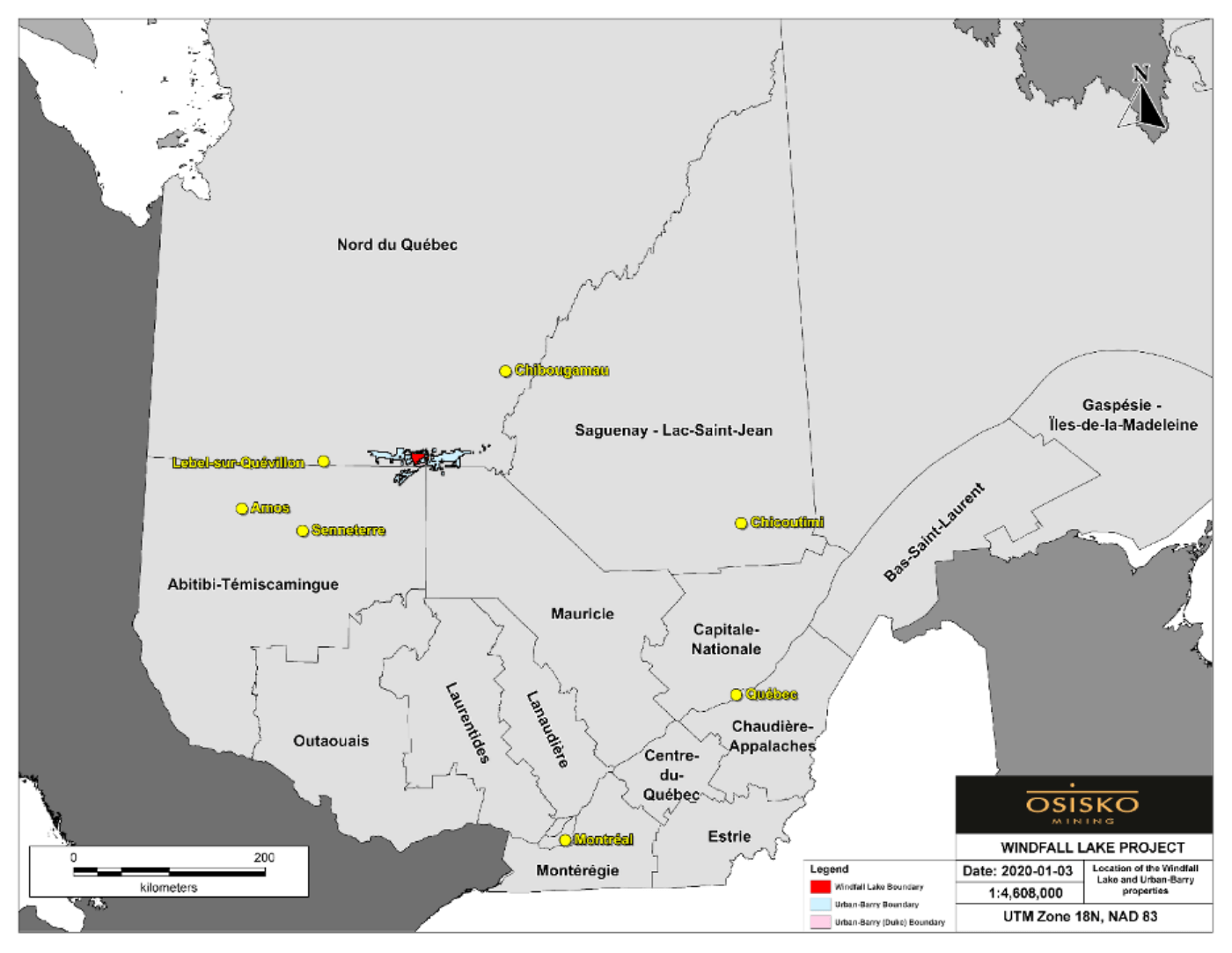
Figure 1: Map showing the location of the Windfall project.
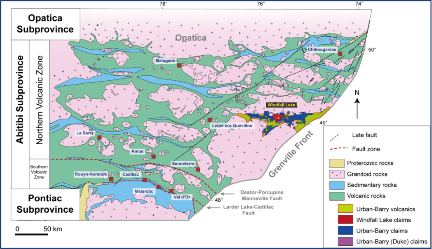
Figure 2: Simplified regional geology map showing the location of the Urban Barry greenstone belt.
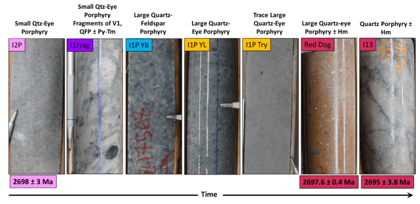
Figure 3: Representative photographs of syn-deformation QFP intrusive rocks from the Windfall intrusive complex in order from earliest to the latest . Dating of the I2P and of the Red Dog dike were done using TIMS U-Pb of zircon by D. Davis at the University of Toronto. The dating of the I13 dike was done by C. Azevedo using HR-ICP-MS U-Pb of zircon at the Geotop Laboratory at the University of Québec.
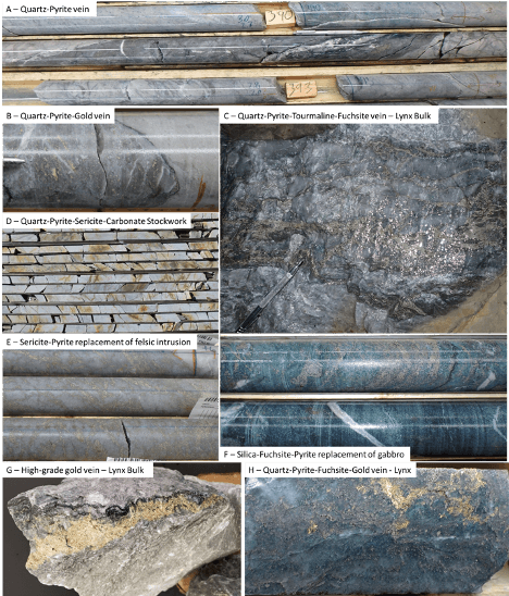
Figure 4: Representative photographs of significant gold mineralisation styles in the Windfall deposit.

Figure 5: Mineralized domains modelled in the Windfall deposit A) Longitudinal view (looking northwest); and B) Cross-section view (looking northeast). Source: Osisko, 2022.

Figure 6: Cross-section of the Lynx Zone. Source Osisko.

Figure 7: Cross-section of the Main and Underdog sectors.
Press Release Maps
26/03/2019
Chargeability Signature Triple8 Area Southwest Plan View26/03/2019
Chargeability Signature Triple8 Area Southeast Longsection View26/03/2019
Chargeability Signature Triple8 Area South Inclined View26/03/2019
Chargeability Signature Triple8 Area Northeast Long-section View26/03/2019
Cross Sections
Long Sections
Drill Results
Windfall - 2015_2021 updated
18/08/2021
Download ViewWindfall - December 2020
01/12/2020
Download ViewWindfall - October 2019
01/10/2019
Download ViewWindfall - June 2019
01/06/2019
Download ViewWindfall - March 2019
01/03/2020
Download ViewWindfall - January 2019
01/01/2019
Download ViewWindfall - October 2018
01/10/2018
Download ViewWindfall - August 2018
01/08/2018
Download ViewWindfall - May 2018
01/05/2020
Download ViewWindfall - January 2018
01/01/2018
Download ViewWindfall - December 2017
01/12/2017
Download ViewWindfall - November 2017
01/11/2017
Download ViewWindfall - October 2017
01/10/2017
Download ViewWindfall - September 2017
01/09/2017
Download ViewWindfall - August 2017
01/08/2017
Download ViewWindfall - July 2017
01/07/2017
Download ViewWindfall - May 2017
01/05/2017
Download ViewWindfall - March 2017
01/03/2017
Download ViewInfrastructure
Surface Infrastructure
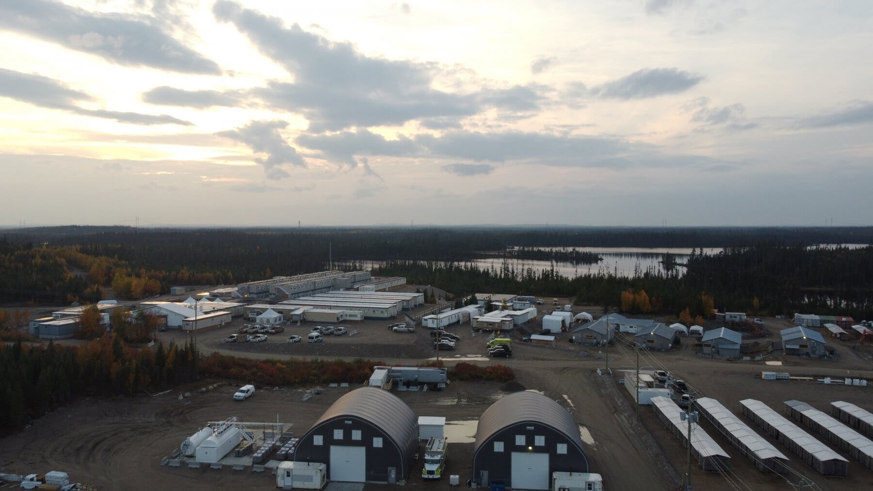
The Windfall area is accessible year-round and is serviced by a complete network of well-maintained logging roads.
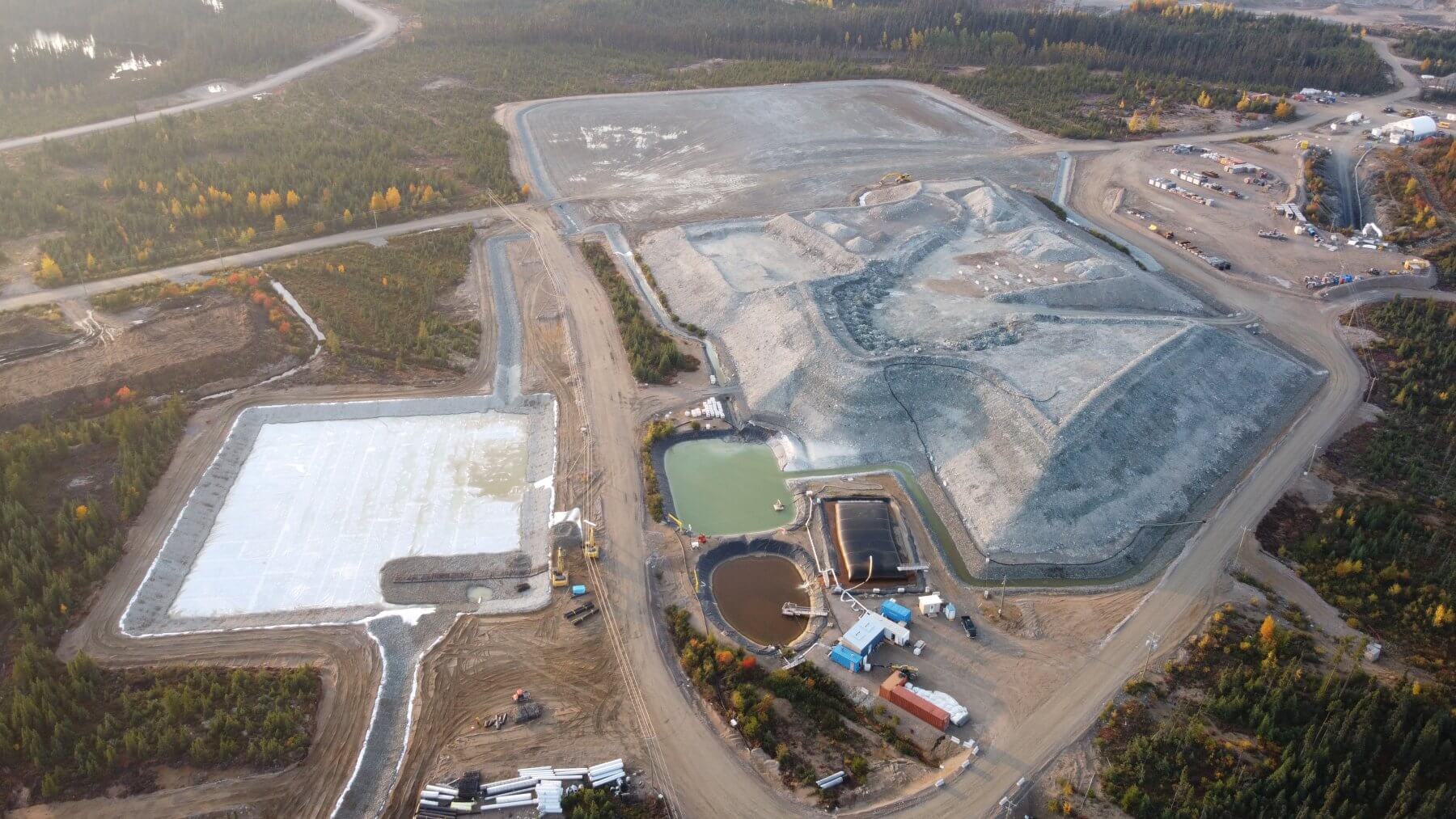
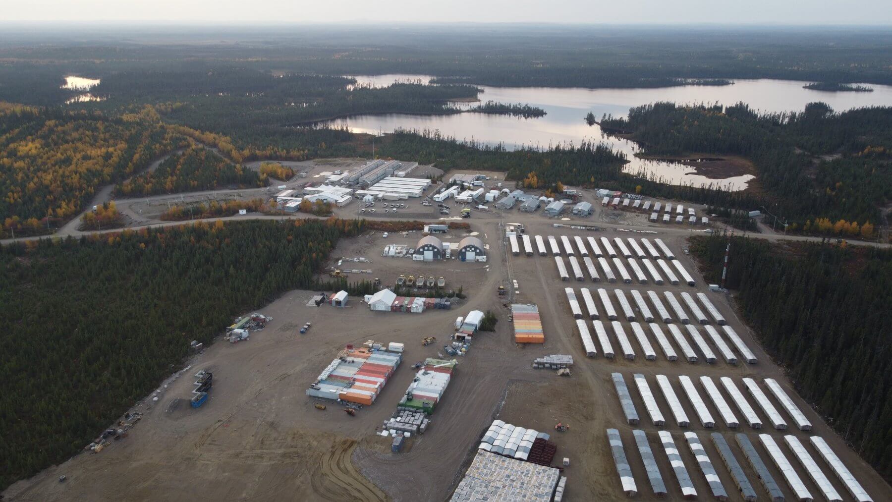
The Windfall project benefits from existing infrastructure developed during the Exploration stage. The following buildings and infrastructures are considering existing:
- Windfall site access road;
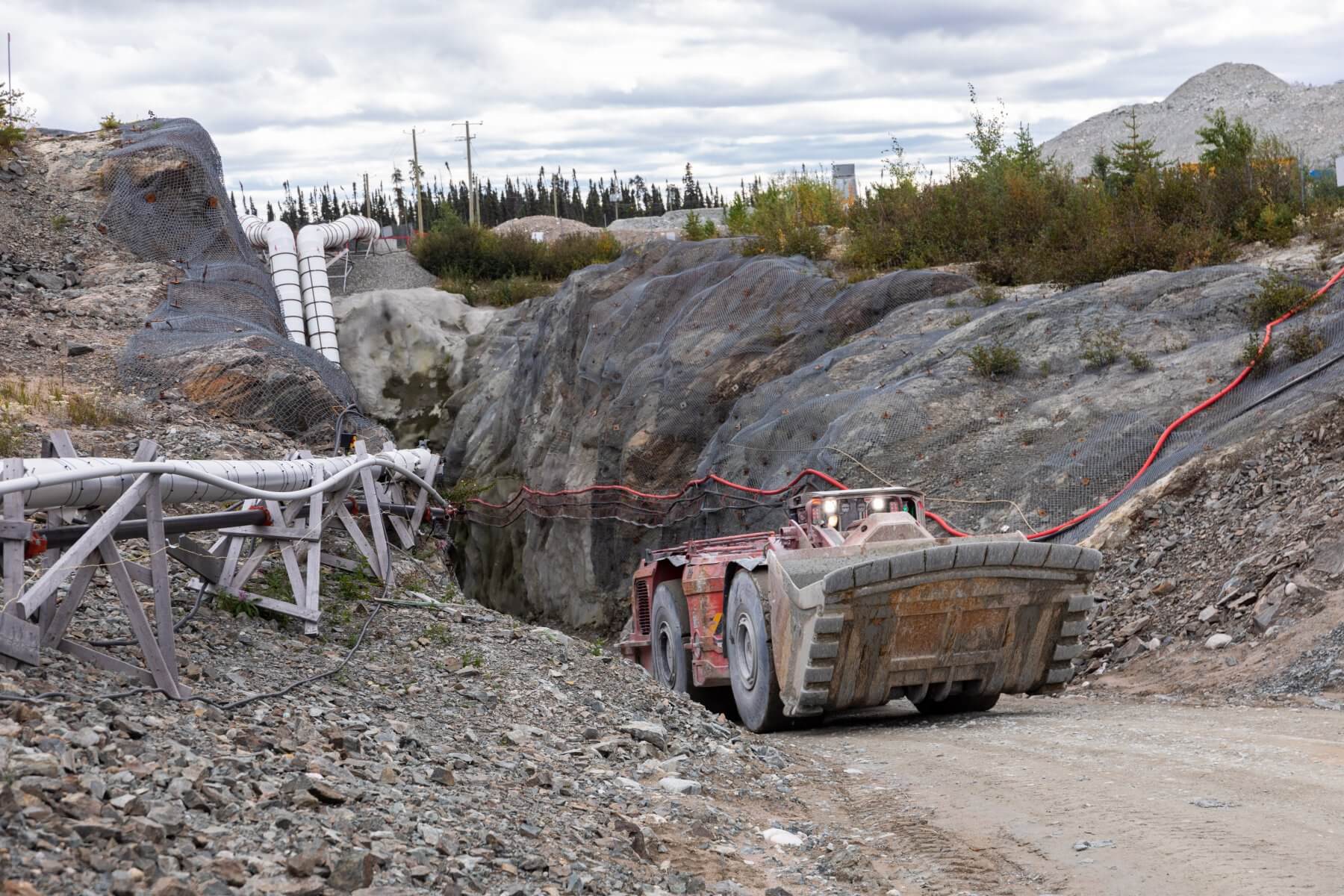
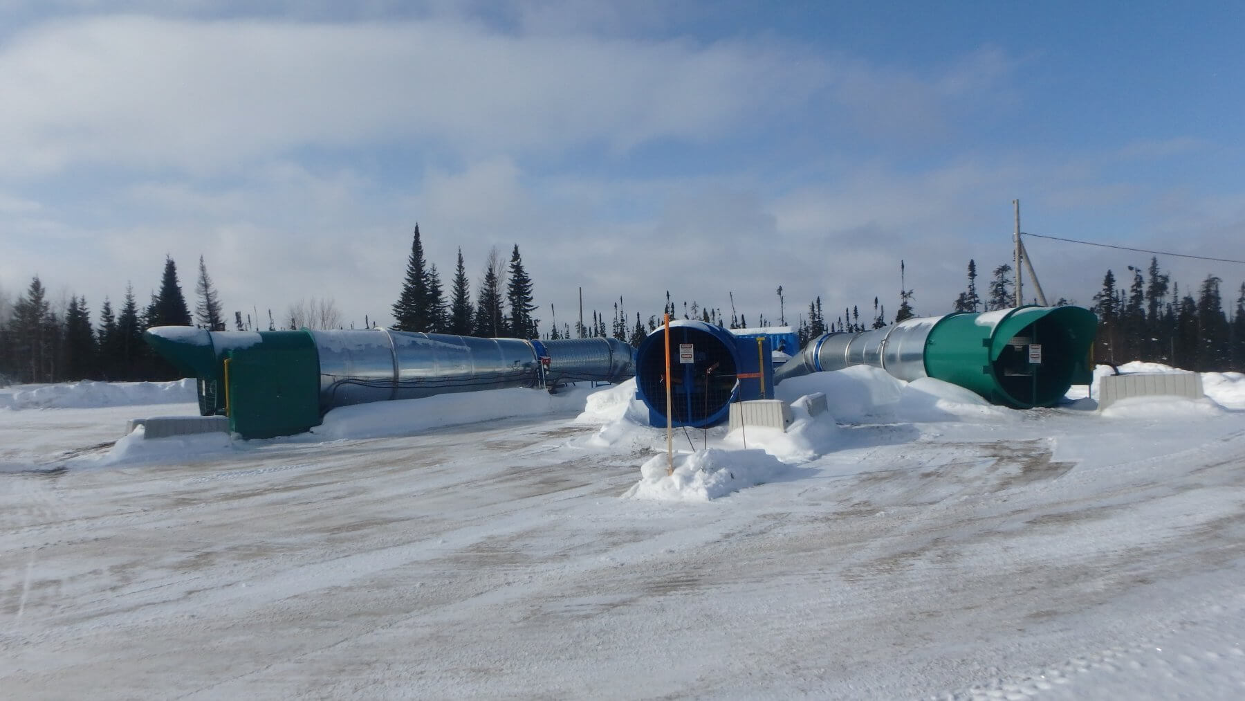
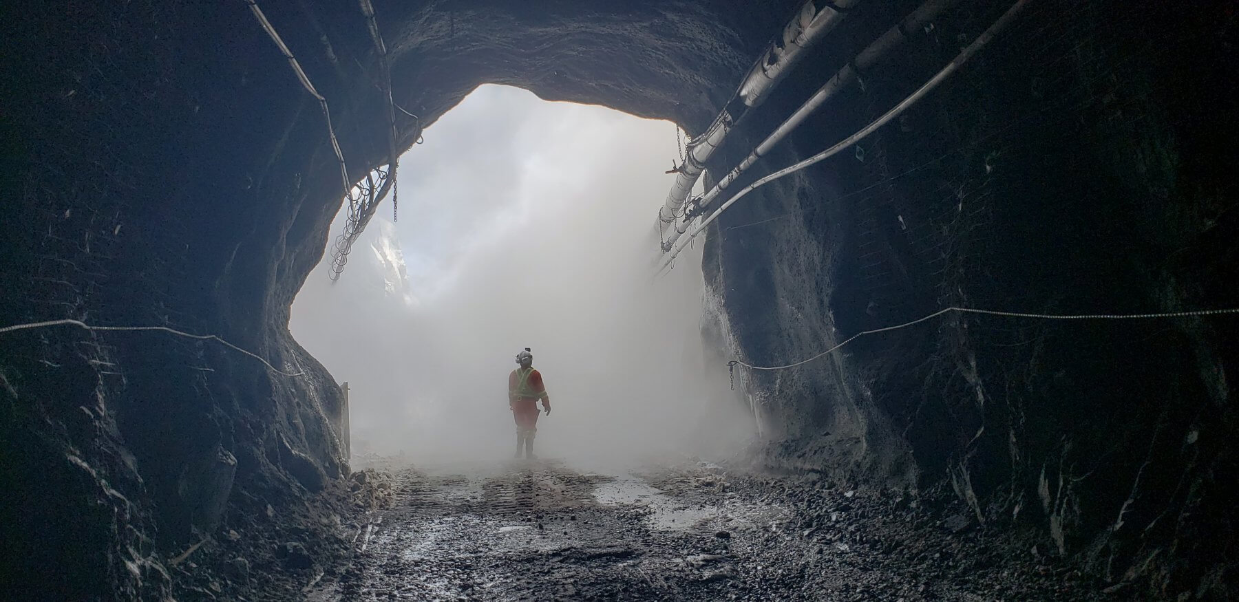
- Main zone portal with underground mine services (compressed air, electricity, ventilation intake);
- Waste rock stockpile;
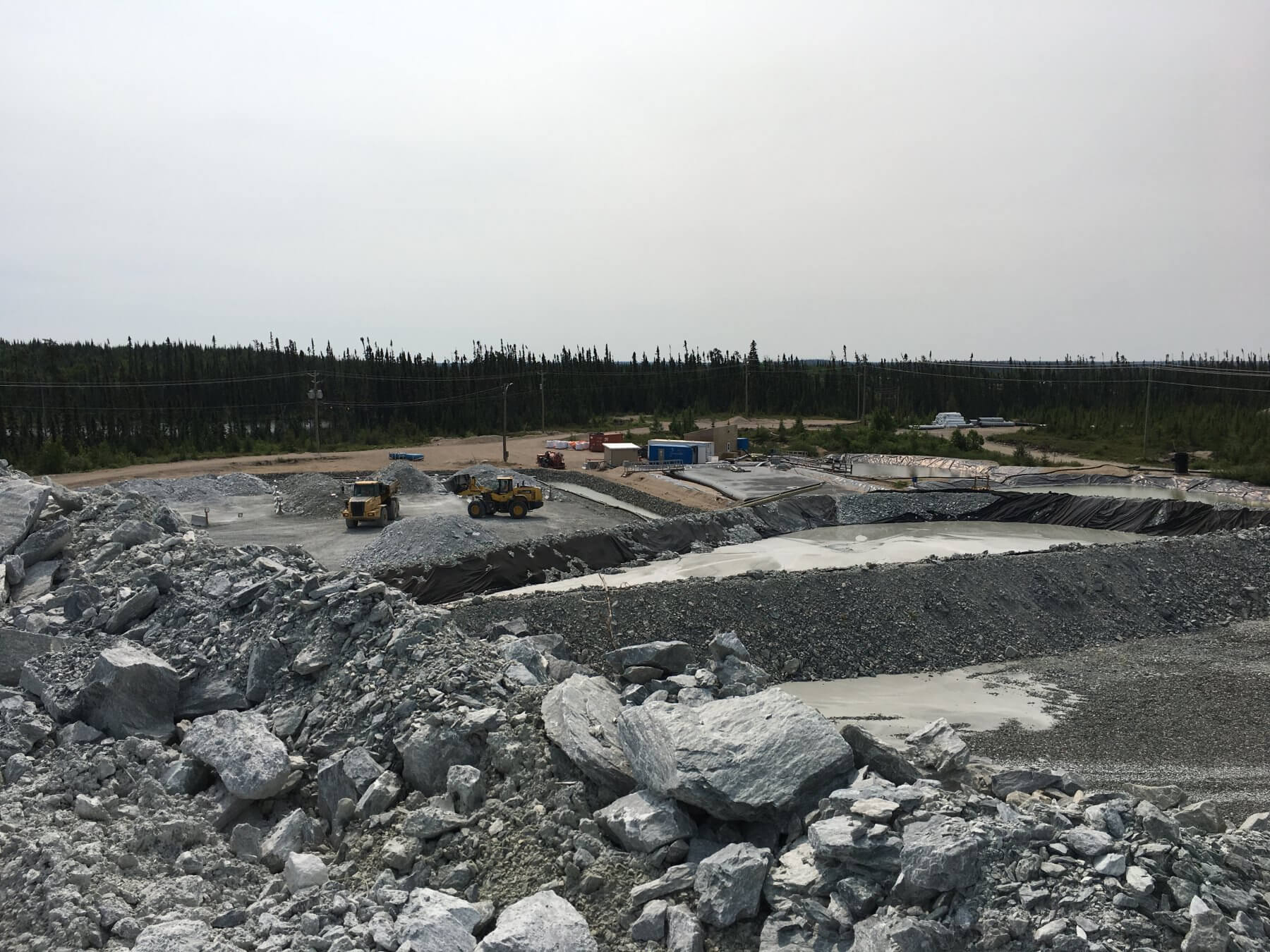
- Surface water management ditches, ponds and pumping stations;
- Water treatment plants;
- Exhaust raise and fan;
- Hybrid secondary WAN link (fibre optic and microwave radio);
- Light structure, fabric-covered domes;
- Meteorological station;
- Borrow pit;
- Diesel generators;
- Telecommunication tower and prive LTE system for the surface and underground mine;
- 300-person capacity exploration camp complex, including potable water and sewage systems;
- Helipad;
- Core logging buildings;
- Storage domes;
- Overhead power lines and camp area genset.
Environment
Environmental Impact Assessment
EIA Summary
March 29, 2023
Download ViewEIA – Volume 1A
March 29, 2023
Download ViewEIA – Volume 1B
March 29, 2023
Download ViewEIA – Volume 2
March 29, 2023
Download ViewEIA – Volume 3-4-5
March 29, 2023
Download ViewEIA – Volume 6
March 29, 2023
Download ViewEIA – Volume 7
March 29, 2023
Download ViewEIA – Volume 8
March 29, 2023
Download ViewSectorial Reports
Air (French)
March 29, 2023
Download ViewAquatic Fauna (fish) (French)
March 29, 2023
Download ViewArchaeology (French)
March 29, 2023
Download ViewAvifauna (birds) (French)
March 29, 2023
Download ViewChiroptera (bats) (French)
March 29, 2023
Download ViewClimate Change Resiliency (French)
March 29, 2023
Download ViewEconomic Spinoffs (French)
March 29, 2023
Download ViewGeochemistry (French)
March 29, 2023
Download ViewGreenhouse Gases (French)
March 29, 2023
Download ViewGroundwater (French)
March 29, 2023
Download ViewHerpetofauna (reptiles and frogs) (French)
March 29, 2023
Download ViewHydrogeology (French)
March 29, 2023
Download ViewHydrologie (French)
March 29, 2023
Download ViewLarge Mammals (French)
March 29, 2023
Download ViewMicromammals (French)
March 29, 2023
Download ViewNoise & Vibrations (French)
March 29, 2023
Download ViewSoil (French)
March 29, 2023
Download ViewSurface Water & Sediments (French)
March 29, 2023
Download ViewVegetation (French)
March 29, 2023
Download ViewClosure Plan
2022 Closure Plan – Advanced Exploration (French)
March 29, 2023
Download View2022 Closure Plan – Advanced Exploration – Additional Information (French)
March 29, 2023
Download View2023 Closure Plan – Operations – Volume 1 (French)
March 29, 2023
Download View2023 Closure Plan – Operations – Volume 2 (French)
March 29, 2023
Download View